|
|||||||||||||||||
|
|
|||||||||||||||||
| |
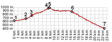
1.(00.0km,622m) START-END SOUTH: jct D10 - D427, along Vallon des
Molans
2.(03.0km,690m) route turns right onto D427
3.(04.5km,760m) Saint Antonin
4.(08.6km,972m) jct D427 - D27; profile turns left
5.(08.7km,987m) TOP: point of highest altitude
6.(14.3km,876m) profile turns right onto D2211A at Col St Raphael
7.(22.3km,406m) START-END NORTH: Puget - Theniers: bridge across Var
View eu_D27-D427_Rourebel_sh in a larger map |