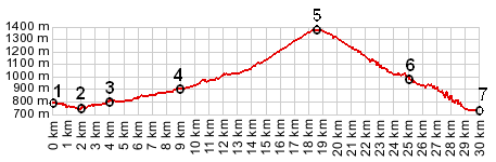
1.(00.0km,780m) START-END SOUTH ALT.: Valbonnais
2.(02.0km,748m) START-END SOUTH: jct with route to Col Parquetout, north of Les Angelas
3.(04.0km,793m) Entraigues
4.(08.9km,896m) Le Perier
5.(18.7km,1373m) TOP: col d'Ornon
6.(25.0km,980m) jct with route to Col du Solude on right
7.(29.8km,734m) START-END NORTH: jct D526 - D1091, just north of le Bourg d'Oisans