|
|||||||||||||||||
|
|
|||||||||||||||||
| |
|
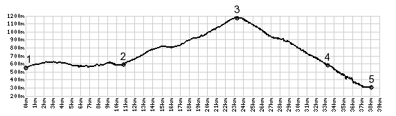
Col De Plainpalais
This pass connects the Bauges Massif with Lac du Bourget.
Several other passes fit that description also. In
Leschergaines le Pont four roads meet and three of them lead
to passes. This is actually the highest one of the four. In
spiet of this it is not very alpine in nature, but instead
crosses a high forested plateau in the Bauges Massif west of
Chambery. From the top you can climb higher on a loop with
short additional out and back to Mont Revard, the highest
road point on the east side of Lac du Bourget.
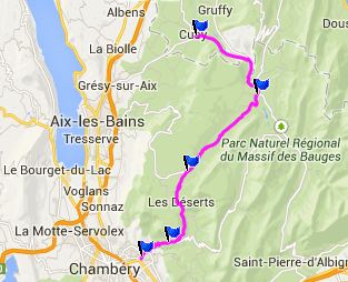
From South. (described downwards).
Immediately after the top a turnoff to the right leads to the
higher Mont Revard. Going down towards Chambery, there is a nice
far vista of the Belledone Range. After that a high speed
descend may make it difficult to stop the bike on a dime, just
to take a picture. Only a few tight turns at the bottom slow
down the fast descend. The main road reaches the valley south of
Chambery. There are serveral worthwhile detours that stay up in
the limestone cliffs a little longer and detour to the south to
Thoiry and Curienne. Dayride with this point as highest summit: Col de Plainpalais , Col du
Frene , addtional out and back : la Ravoire > bike
path with detours south to Montmelian > Cruet <> out
and back quite a ways up small road to Combefolle > St
Piered'Abigny > Col de Frene > Epernay > Chatelard >
Leschergaines > Col de Plaipalais > back to starting point
in La Ravoire: 58.4miles with 6027ft of climbing in 5:41hrs
(Garmin etrex30 m4:14.7.6) The last day with different start and end points over a pass on this tour is on page: D207 Aiguebelle - St Pierre de Belleville(s)
|
|
|
advertisement |
|
|
advertisement |