| |
|
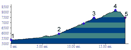
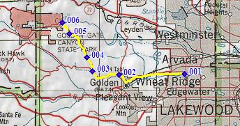
01.(5360ft,mile00) START-END EAST ALT: jct: Clear Creek bike path - Kippling Ave.
02.(5930ft,mile08) START-END EAST: beginning of Golden Gate Canyon Road, just north of Golden
03.(6920ft,mile12) Crawford Gulch Road diverts on right
04.(7470ft,mile14) intermediate shoulder summit
05.(8210ft,mile17) TOP
06.(7490ft,mile18) START-END WEST: low point on Ralston Creek road