| |
|
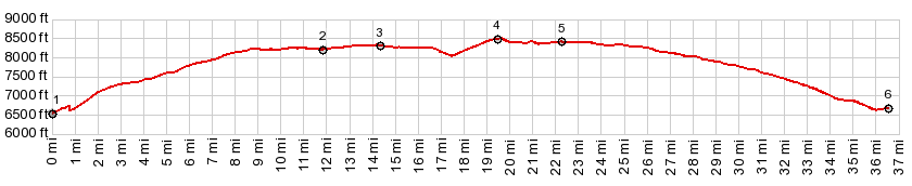
1.(00.0mile,6540ft) START-END EAST:bridge
over Dolores at Bradfield Recreation Area
2.(11.8mile,8210ft)profile turns hard left from FR521
onto FR514
3.(14.3mile,8320ft)intermediate high point
4.(19.6mile,8530ft)TOP:jct FR514-FR240,turnoff to
Benchmark Lookout
5.(22.3mile,8410ft)profile turns left onto FR514
6.(36.5mile,6670ft) START-END EAST-2: profile rejoins
FR514, a short distance above the starting point at
point 1.
|