| |
|
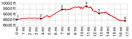
2.(mile03.7,8640ft)FR75 exits Big Red Park after crossing Middle Fork of Little Snake River
3.(mile07.0,9470ft)Continetal Divide Trail joins road from south/east
4.(mile10.8,9770ft) TOP: high point
5.(mile12.7,9120ft)CD Trail and profile separate, at end of steep, rocky section
6.(mile16.7,8430ft)START-END NORTH: low point on road, immediately before reaching Hog Park Reservoir
|