| |
|
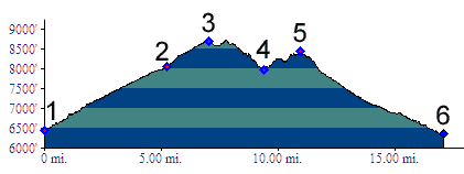
1.(6450ft,mile00) START-END NORTH: jct : Colorado River Road - Derby Mesa (dirt) road in Derby Junction.
2.(8050ft,mile06) route turns right onto FR611 High Trail
3.(8689ft,mile08) TOP: point of highest altitude, labeled on USGS topo maps
4.(7950ft,mile10) intermediate low point
5.(8430ft,mile11) intermediate high point
6.(6370ft,mile17) START-END SOUTH: jct: Colorado River Road - dirt road up Red Dirt Creek
