| |
|
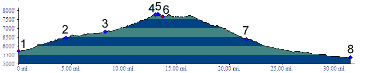
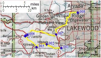
01.(5720ft,mile00) START-END SOUTH: Morrison, jct C470 - Bear Creek Canyon
02.(6470ft,mile05) Idledale and (dirt) turnoff to Grapevine/Sawmill Gulch is on right
03.(6810ft,mile08) profile turns right up Kerr Gulch, just before turnoff to Parmalee Gulch (aka Myers Gulch or Dix Saddle) and town of Kittredge
04.(7780ft,mile14) profile joins Co74 and turns right to El Rancho
05.(7810ft,mile14) TOP
06.(7670ft,mile14) El Rancho
07.(6400ft,mile22) START-END EAST ALTERNATE: turn from Mount Vernon Canyon left onto US40 which becomes Colfax Ave.
08.(5360ft,mile32) START-END EAST: Clear Creek bike path at Kipling Ave.