| |
|
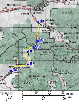
1.(6166ft,mile00) START-END NORTH: Carbondale
2.(7150ft,mile15) northern turnoff to Redstone
3.(7196ft,mile16) START-END NORTH ALTERNATE: southern turnoff to Redstone
4.(7545ft,mile23) turnoff to Marble and Schofield Pass on left
5. (8763ft,mile26) TOP: Mc Lure Pass
6. (6896ft,mile32) Henderson Creek dirt road is on left
7. (6416ft,mile43) turnoff to Kebler Pass road is on left
8. (5738ft,mile58) turn off to left to reach Paonia
9.(5676ft,mile59) START-END SOUTH Paonia