| |
|
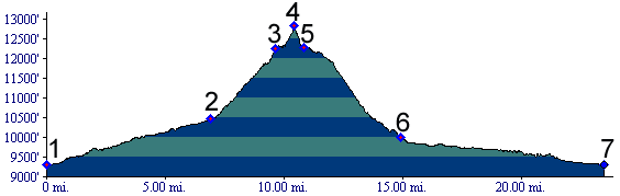
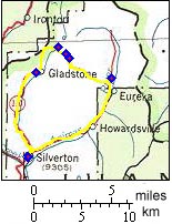
1.(9300ft,mile00) START-END SOUTH-EAST: downtown Silverton
2.(10460ft,mile01) Gladstone, route continues up steep dirt road on right signed for Hurricane and California Pass
3.(12290ft,mile07) route takes right fork, deviation from Hurricane Pass
4.(12780ft,mile10) TOP: Sunnyside Saddle
5.(12270ft,mile11) Sunnyside mining reclamation area with nonexistent Lake Emma
6.(9990ft,mile11) Eureka Gulch terminates in Animas Canyon. Profile continues to right, back to starting point.
7.(9300ft,mile24) START-END NORTH-EAST downtown Silverton