| |
|
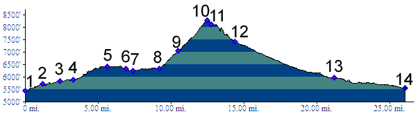
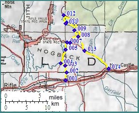
01.(5440ft,mile00) START-END WEST: Silt, US6 and Main street, head north.
02.(5730ft,mile02) stay left
03.(5850ft,mile03) stay left
04.(5880ft,mile04) stay right for Harvey Gap shoulder summit
05.(6430ft,mile06) Harvey Gap shoulder summit
06.(6320ft,mile07) stay right towards New Castle
07.(6250ft,mile08) stay left towards CR247-245 shoulder summit
08.(6330ft,mile09) go right through gate to start of BLM 8114 West Ridge Road
09.(7070ft,mile11) stay right downhill, instead of going uphill on left
10.(8270ft,mile13) TOP
11.(8100ft,mile13) continue right above red rock formation
12.(7410ft,mile14) junction with Buford Road. Profile continues downhill to right
13.(5910ft,mile21) junction Buford Road - Grass Valley Road
14(5560ft,mile26) START-END - EAST: New Castle: jct US6-Grass Valley Road