| |
|
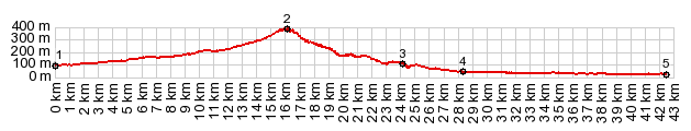
1.(00.0km,100m)START-END SOUTH: Rm-F20, just west of Balsicas
2.(16.3km,380m)TOP
3.(24.2km,100m)settlement: Cabezo de la Plata
4.(28.4km,050m)START-END NORTH: profile turns west and traverses, slightly above the valley of the Orihuela
5.(42.6km,020m)START-END NORTH ALT: Orihuela
|