| |
|
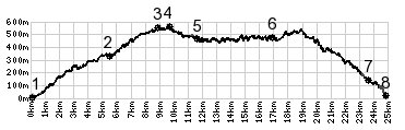
1.(10m,00.0km) START-END EAST: beach in Monterosso a Mare
2.(340m,05.6km) profile turns right onto Cinque Terre road
3.(540m,5.5km) Foce de Termine, route stays right at this
intersection
4.(550m,9.7km) TOP: highest point of altitude
5.(470m,11.6km) earstern turnoff to Vernazza
6.(470m,17.0km) western turnoff to Vernazza and Corniglia
7.(180m,23.6km) profile turns right, from Cinque Terre
road to Riomaggionr
8.(20m,24.9km) START-END WEST: Riomaggiore, western side;
the last part of this is a footpath