| |
|
1.(00.0km,0720m) START-END EAST: N141 branches off N230, just south of Bossost
2.(08.4km,1293m) TOP: Col de Portillon
3.(17.2km,0650m) START-END WEST: Saint Mamet
|
|
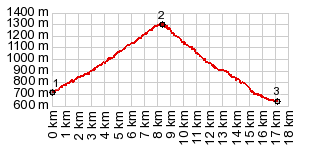
1.(00.0km,0720m) START-END EAST: N141 branches off N230, just south of Bossost 2.(08.4km,1293m) TOP: Col de Portillon 3.(17.2km,0650m) START-END WEST: Saint Mamet
|