| |
|
|
|
us local units:
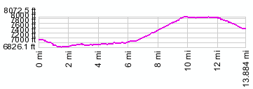
01.(mile00,7120ft) START-END EAST: jct Mo296-Beartooth Highway)
02.(mile01,6890ft) START-END EAST ALTERNATE: low point when crossing Gilbert Creek
03.(mile09+1/2,8100ft) point of highest altitude
04.(mile12,8066ft) Colter Pass
05.(mile14,7640ft) START-END WEST: Cooke City
metric:
01.(km00.0,2170m) START-END EAST: jct Mo296-Beartooth Highway)
02.(km02.8,2100m) START-END EAST ALTERNATE: low point when crossing Gilbert Creek
03.(km17.6,2470m) point of highest altitude
04.(km19.2,2458m) Colter Pass
05.(km22.3,2330m) START-END WEST: Cooke City
| |