|
|
|
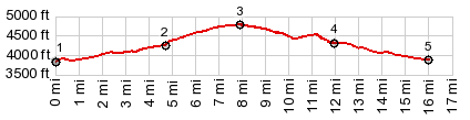
1.START-END NORTH:jct US93 - Lost Horse
Rd, south of Hamilton
2.profile turns left onto FR5621
3.TOP:4760ft: FR5621 Como Lake s(u)
4.south end of dam on Como Lake
5.START-END SOUTH:jct US93 - Como Lake Rd
|