|
|
|
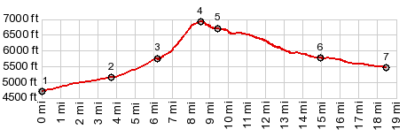
1.START-END WEST: jct Dry Creek Rd - Pass
Creek Rd
2.Pass Creek Rd meets Rocky Mtn Rd. It continues a
little to the south
3.National Forest boundary
4.TOP: 6920ft, Flathead Pass
5.jct with alternate approach of stock trail road
6.jct with Middle Fork Flathead Creek Rd
7.START-END EAST: jct Mo86 - Flathead Pass Rd
|