| |
|
|
|
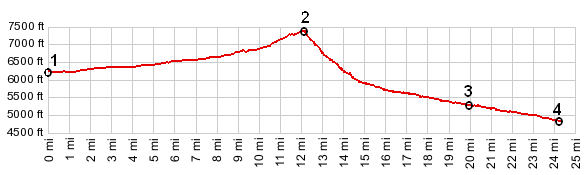
1.(00.0km~00.0mi, 1896m~6220ft)
START-END EAST: Mo324 - Lemhi Pass Road at Shoshone
Ridge
2.(19.5km~12.1mi, 2249m~7378ft) TOP: Lemhi Pass and
jct with Warm Springs Road
3.(32.0km~19.9mi, 1613m~5292ft) route stays left at
this fork
4.(39.0km~24.2mi, 1485m~4872ft) START-END WEST: jct
Lewis and Clarke Hiway - Id28, Tendoy
|
|