| |
|
|
|
local units
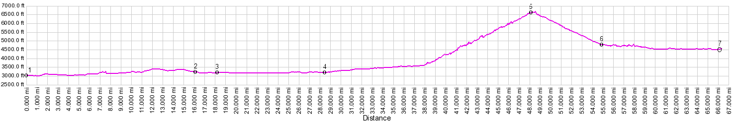
01.(000.0m,3028ft) START-END EAST: Columbia Falls
02.(016.1m,3228ft) Going to the Sun Hwy diverts from US2 on left, and profile follows it.
03.(18.2m,3195ft) START-END EAST ALTERNATE: turnoff to campground on south side of Lake McDonald.
04.(28.4m,3241ft) north end of Lake Mc Donald
05.(47.9m,6646ft) TOP: Logan Pass
06.(54.7m,4770ft) road reaches west end of Saint Mary Lake
07.(66.0m,4528ft) START-ENE WEST: jct US89 - Going to the Sun Road
metric units
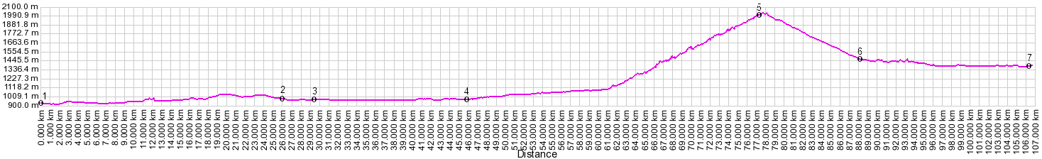
01.(000.0km,923m) START-END EAST: Columbia Falls
02.(026.0km,984m) Going to the Sun Hwy diverts from US2 on left, and profile follows it.
03.(029.3km,974m) START-END EAST ALTERNATE: turnoff to campground on south side of Lake McDonald.
04.(045.8km,988m) north end of Lake Mc Donald
05.(077.1km,2026m) TOP: Logan Pass
06.(088.1km,1454m) road reaches west end of Saint Mary Lake
07.(106.2km,1380m) START-ENE WEST: jct US89 - Going to the Sun Road
|
|