| |
|
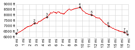
1.(6340ft,mile00.0)START-END SOUTH: jct Nv207-US50, north of South Lake Tahoe
2.(7250ft,mile02.7)route turns left onto North Benjamin Dr near top of Daggett Pass
3.(7820ft,mile04.7)START-END SOUTH ALTERNATE: TRT trailhead and start of Geona Peak Rd
4.(8720ft,mile09.7)TOP: point of highest altitude
5.(8020ft,mile11.05) road crosses TRT
6.(7010ft,mile14.1)START-END NORTH ALTERNATE: profile turns from dirt road onto US50 west
7.(6450ft,mile16.4)jct US50 - Glenbrook Rd, near shore of Lake Tahoe8.(6250ft,mile16.9)START-END NORTH: Glenbrook Rd access to Lake Tahoe
|
![]()