| |
|
-
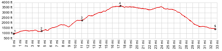
1.(990ft,mile00.0)START-END WEST-ALT: jct Green Point Rd - Or281
2.(1240ft,mile04.6)jct with Green Point Rd on right
3.(2300ft,mile11.1)START-END WEST: profile turns right climbing onto FR16
4.(3750ft,mile17.2)TOP: point of highest elevation on FR16
5.(1420ft,mile32.7)START-END EAST: jct Old Parkdale Rd - Or281
View Or_fr16_vista_ridge_u.gpx in a larger map |
-