| |
|

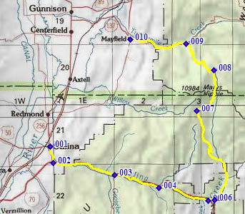
01.(5160ft,m00) START-END SOUTH: Salina:
jct US50 -US89
02.(5310ft,m02) route turns 90 degrees left onto I70
03.(5760ft,m09) profile exits I70 at Gooseberry Rd exit
04.(6190ft,m14) FR004 Water Hollow Rd turns off on left
05.(6770ft,m20) profile exits I70 and turns north on
paved road
06.(6840ft,m21) profile turns left up FR009, following
Salina Creek
07.(8990ft,mile33) route turns right onto FR001, below
Mary's Nipple
08.(9670ft,mile39) TOP: highest point, immediately
before turning down FR290 on right
09.(6560ft,mile45) profile turns left down FR022,
Mayfield - Ferron Road
10 (5530ft,mile51) START-END NORTH: downtown Mayfield