| |
| |
Argentine Pass
Argentine Pass is often said to
be the highest double tracked mountain pass in
Colorado, even if only one approach side fits that
description these days. Argentine Pass is not on
the continental divide. The honor of the highest
continental divide pass goes to Mosquito Pass.
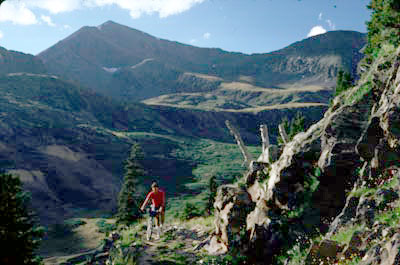
Still, with its high distinction Argentine Pass
offers up some special difficulties and
attractions. In the attraction department, this is
as alpine as it gets. 14000 foot peaks, Grey's and
Torrey's Peaks are what seems a stones throw away,
on the other side of a gaping tundra trough. In
the difficulty department, the east side is
reasonably bikable. However the west side most
likely requires a lot of walking, portaging, -
maybe some route finding.
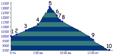
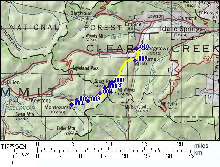
From West. It has been a long time since I have done this. So I can't remember the details at this point. But - between points 1 and 4, the route follows a dirt road in the valley. Past there, the approach is largely on a steep hiking trail. Extensive walking is most likely necessary. I know I did. Portaging the bike up a steep mountain side is also an option. From East. (also described upwards) The profile includes the initial approach on the Guanella Pass road between points 9 and 10. Continuing to the top, the route is a jeep trail, at times very ridable, at other times very rocky. Crossing the past from west to east (going down this side) is in my opinion preferable, because descending on this side is less troublesome than on the other side. Going up either side is likely to be fairly slow for normal people, walking or riding. Dayrides with this point as highest summit:Argentine Pass , Webster Pass , Guanella Pass , Hepburn Pass: Georgetown > Guanella Pass > Burning Bear Trail north > Hepburn Pass > Webster Pass > Montezuma > road up Peru Creek > Argentine Pass > Georgetown: 58.1miles (mech Odo m1:87.8.8). Notes: This "ride" was much longer than first thought. We reached the top of Argentine pass just shortly before sunset, when the picture below was taken. - return after dark. 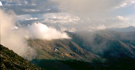 History Colorado gold rush of 1859/60 (<Jones Pass|Webster Pass>):
Several passes were pioneered long after the
initial two years of the gold rush. Their purpose
was to serve as easier supply routes to the gold
camps. All of these involved crossing the
continental divide west of Denver. A previous
attempt to ease movement of goods to the mining
towns west of the divide was over Jones Pass. Argentine Pass was the most direct attack on the
wall between the mining towns and Denver. The
previous pass in this thread, Jones Pass, had no
affect on the movement of goods for the majority
of mining towns, which are located further south.
The problem remained the long and complicated
route to Denver. In order to get to the Front
Range, Breckenridge miners had to cross Boreas Pass, South
Park and Kenosha Pass.
By this time another wagon road had been opened
over the continental divide west of Denver over Rollins Pass. But
that did not do much for the Breckenridge area.
That pass also was too far north. All through the
1860s silver had been found on the west side of
what would become Argentine Pass. So close to
Denver, yet its distance to be traveled to a mill
was over 200 miles. Georgetown, east of the ridge,
and all its adjoining wealth and industry, was
less than a dozen miles away as the crow flies. If
only a road could get across that ridge.
Motivation to build a road was very high, and so
was the pass that resulted.
So how did Silveropolis turn out ? Incredibly
Argentine Pass was built from Georgetown to the
top in 1869 and started cutting down the other
side during the spring of 1870. By the time the
first toll gate was installed at Waldorf, our hero
Decatur was drinking heavily and resigned from the
Georgetown Snake River Wagon Company, maybe to
promote his Silveropolis. That was just as well. The road was blocked with
snow except for July to September. And when the
road was cleared of snow, chances were high that
it was blocked by a rockslide. Paying customers of
the road were forced to clear the road themselves,
on top of doubling and tripling their wagon teams.
But 1877 the road had essentially become a pack
train trail. Another pass was built to address the
original problem in 1878, Webster Pass.
 |
 Approaches
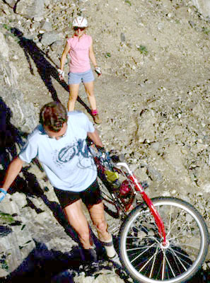 The business man for such a venture
had to have a matching ego. Stephen Decatur also
had business dealings and wives to match the ego,
5 children from 2 white and several Indian wives.
His motto was "no orthodoxy, no monogamy and no
monotony". If he had his way, the capital of the
new mining district that was to be created from
his road, would be called Silveropolis
The business man for such a venture
had to have a matching ego. Stephen Decatur also
had business dealings and wives to match the ego,
5 children from 2 white and several Indian wives.
His motto was "no orthodoxy, no monogamy and no
monotony". If he had his way, the capital of the
new mining district that was to be created from
his road, would be called Silveropolis|
|
advertisement |
|
|
advertisement |