| |
| |
Buzzard - Muddy Divide
Some Colorado passes attract tourists from far and wide to their scenic splendors. The Buzzard Divide is not one of them. What would you expect from a divide, crossing between Oil Well Mountain and Bronco Knob, wild horses and gas wells ? Half right, the second half. Only one gas well is visible from the road. But there are many hidden in the nearby hills (as of Oct/05). It is hard to find this divide labeled on a map. It is not labeled on topographic or national forest maps. It is included in Helmuth's book Passes of Colorado" under the name Buzzard Pass. But the description given there fits the unofficial Alkali Creek - Road Gulch s(u) better, connecting Silt and Colbran, instead of Paonia Reservoir and Colbran. Yet this is clearly a historic named pass with plenty of reminders along the way. After this description is virtually impossible to be disappointed by this journey. Actually, given good October weather, this is a fascinating ride through high plateau landscape, across a rarely visited, corner of the state with a fascinating early history.
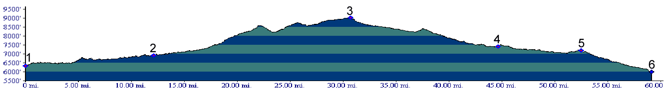
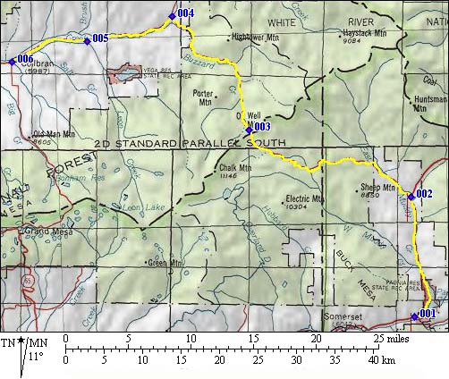 Approaches From West. Dirt/medaled surface road
CR245 leaves the Mc
Lure Pass road between Paonia reservoir and
the summit. A sign on CFR245 warns of heavy truck
traffic. Yet the only heavy traffic I encounter
during a late October ride is a massive amount of
gun toating hunters, tracking down Bambi with
motorized support. The road climbs gently through
ranch country. I turn around every so often to
watch Ragged Mountain take its place in the rest
of the West Elk Mountains. A good view is on the
first high point along the route, between points 2
and 3 on the profile. In my case the spot is
marked by a campfire circle, a disposed Wendy's
cup and thrown away cigarette rolling papers. The
road crosses the National Forest boundary and now
stays in valleys and high rolling plains belonging
to fringes of Grand Mesa and Battlement Mesa. At
least four signs along the way label this route as
Buzzard Divide Road. 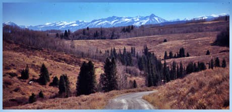 From East. (also described upwards) The
first part of the approach is shared by one
approach to the unofficial Alkali Creek - Road
Gulch s(u). Road surface becomes much better
after the route becomes CR245. Two separate signs
along the way point the way to the divide, here
called Buzzard Divide. After the road makes a
ninety degree turn to the south, along with
Buzzard Creek, the route offers glimpses of the
south side of Grand Mesa and the valley below
Colbran. There is really only one obvious evidence
of civilization in this view, the narrow, almost
thread like road curving up the next valley.
Otherwise the view is virtually identical to what
the Escalante expedition saw. A Day on a Two Day Tour with this point as
highest summit:
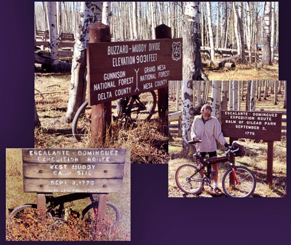
History The north side of the profile shows the quickest way to descend into the valley towards Colbran. However the first human traffic route took a different course. A Ute trail ran over Buzzard Pass, but then turned right near point 4 to cross the Alkali Creek - Road Gulch divide(u), descending Divide Creek or Mamm Creek to the New Castle - Silt area. Escalante
Expedition(<Columbine
Pass|Alkali
Road Gulch summit(u)>): Two
separate signs on the western approach label
Escalante expedition sites. Surprisingly the
Buzzard Divide is on a route, that was intended to
join Santa Fe to California. Less surprisingly,
the Escalante expedition never reached California
on this intended route. Instead they blazed an
adventurous trail of discovery around the Four
Corners area. On the north fork of the Gunnison ( lower Mc Lure Pass east of
Paonia ), the party spent several days
reconnoitering with Laguna Ute and Sabuguana Ute
Indians. Several meetings were spent with trying
to find a guide, willing to lead them north
despite the Ute's perceived fear of Comanche
Indians. After extended pipe smoking, overeating
and social intrigue, the Sabuguana Utes still were
of no help. Instead two Laguna Indians, one of
whom had already served as guide, ( with the name
Silvestre), lead the group over the eastern end of
Grand Mesa over Buzzard Pass. It appears likely
that the lower part of the Escalante route
followed closer to the Hubbard Creek road,
not the Henderson Creek road shown on the profile. Between September 3 and 5 they rode across early
autumn color of the mesa. But this wasn't
mentioned in their journals, just that it was
quite cold. They did take note of an underground
stream at a camp, and named it after their
Indian guide, camp Silvestre. The spot is marked
today with a sig ( picture is included ). Near Colbran the party discovered that they could
have crossed the Mesa by a trail heading straight
over the top. Perhaps emboldened by this, author
Walter Briggs in "Without Noise of Arms" has them
heading straight across Battlement Mesa
subsequently. An older interpretation of the
journals by Marshall Sprague has them crossing the
area of the Alkali -
Road Gulch divide(u) to reach the Colorado
River near Silt. Unless they were lost, which they
did not mention in their journals, this second
crossing is much easier and seems more likely to
me, than higher areas of Battlement Mesa. Whichever route they chose to reach the Colorado
River, reach the Colorado River they did, and that
was the end of the great detour to the east, which
was initially begun to avoid stretches of Utah
dessert. The expedition descended along the
Colorado, crossed it near De Beque and used Roan
Creek to approach the area of today's Douglas. Pass.
|
|
|
advertisement |
|
|
advertisement |