| |
| |
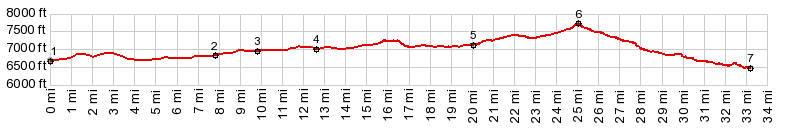
CR52 Wolf Creek s(u)
This gentle good dirt road summit
is in the rangeland west of Steamboat Springs.
Public roads in this particular corner of the
state are a rare commodity. Ranches are in control
of most of the land here. Still, if leaving from
Steamboat Springs, this summit opens up a few
unpaved loop ride possibilities.
From the lower part of this paved road, unpaved
but smoothly surfaced CR56 runs up Long's Gulch.
But any number of roads can be used to connect to
CR56 or CR52W. On my De Lorme Gazeteer map, a
total of three connections are shown over to CR80
going up to Slater. CR52 is just one of them. The
other two are CR56B around Nipple Mtn and CR56
through the Deep Creek STL.. But the planned route over CR56 has been taken
over by the owners of the Haystack Ranch. I asked
a ranch worker, hunting for a lost cow coming from
CR56 about where that road leads. He said he
didn't know, but seemed friendly otherwise. I'm
sure he knew. If somebody coming from there,
looking for a lost cow doesn't know, who would ?
You have to conclude that they instruct their
employees not to give out no information about
roads to anybody. But I still think this may be a
possible route, at least it is according to the De
Lorme Gazeteer map.
From East. (described
downwards) The Wolf Mountain Ranch monopoly
landscape, with the identical intrusive looking
gates ends only after many miles of rolling along.
On the lower part of this canyon are a few
interesting rock outcrops. The road ends on US40
at a bridge over the Yampa river. There is no
legal way to turn off the road before then. A Dayride with this point as intermediate
summit is on page: FR42
Hahn Peak Basin s(u)
|

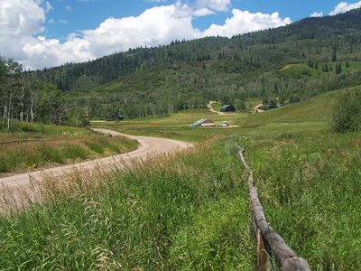 That leaves the obvious way across
the hills over CR52 shown in the profile. This
road leads past countless junctions with good
roads that lead off into the hills. Every single
one is gated, and has the same pedantic looking,
simple three log ranch gate, flanked by countless
no trespassing and further no... signs. Otherwise
the landscape consists of rangeland hills. The top
is a very clearly defined saddle, with yet another
no trespassing ranch entrance leading higher to
the south.
That leaves the obvious way across
the hills over CR52 shown in the profile. This
road leads past countless junctions with good
roads that lead off into the hills. Every single
one is gated, and has the same pedantic looking,
simple three log ranch gate, flanked by countless
no trespassing and further no... signs. Otherwise
the landscape consists of rangeland hills. The top
is a very clearly defined saddle, with yet another
no trespassing ranch entrance leading higher to
the south.|
|
advertisement |
|
|
advertisement |