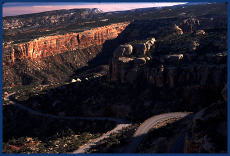
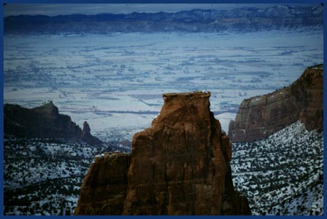
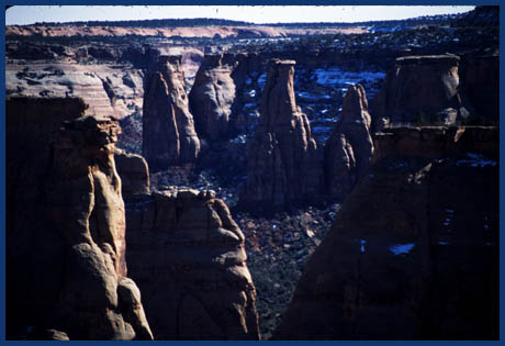
Colorado National Monument summit(u)
Even the Park Service's official map and guide pamphlet
states that Rimrock Drive is ideal for bicycling. I don't
know of any other Park Service Publication that even
mentions bicycling. So it must be good ! And it's true,
the largest portion of road cyclists out and about between
Fruita and Grand Junction are likely to be found on these
30 miles, weather permitting. The word Rimrock Drive just
about says it all, except that it should be called Rimrock
Ride. Traversing the route from Grand Junction to Fruita
lets you ride on the side of the rim and saves the
Monument Canyon overlooks for last, while riding from
Fruita to Grand Junction often provides better light
conditions and hence better views once arriving at the
switchbacks on the eastern side. The ride is short enough
to do both.

click on profile for more detail
|
1.(4500ft,mile00) START-END WEST:
downtown Fruita
2.(4680ft,mile03) go right into Colorado National
Monument
3.(5790ft,mile07) Park visitor center and Saddlehorn
campground are on left.
4.(6470ft,mile14) western turnoff to Glade Park is
on right.
5.(6673ft,mile18) TOP: high point
6.(6211ft,mile22) eastern turnoff to Glade Park is
on right
7.(4951ft,mile26) eastern park entrance
8.(4550ft,mile29) START-END EAST: bridge across
Colorado River. junction of Co140 and road into
Colorado NM.
|
Approaches
From North. Co340 leaves Fruita by crossing I70 and
skirting a few businesses designed to alleviate tourists of
too much time on their hands, such as a Dinosaur Museum, aimed
mostly at children. Rimrock Drive deviates to the right past a
small entrance booth. After gaining a few feet of warm up
elevation, the road starts to traverse up the south side of
Fruita Canyon, only to reverse its course at its head, and
continue to climb back on the other side of the canyon,
utilizing two short tunnels. Now on the slanting plateau
slope, five loosely spaced switchbacks make their way up to
the edge of the plateau.
A campground, picnic ground and visitor center mark the
beginning to the section, that sheds a whole series of views
onto the most striking rock formation along the road, the
Kayenta formation capped monument, named Independence Rock for
patriotic reasons. The road diverges from the rim only for
very short distances. When Independence Rock is is finally
seen the last time, it is from the opposing direction as when
first catching a glimpse of it.
The next set of rock formations to the south lack the hard
Kayenta cap rock and hence have eroded into a series of large
beehive shapes, or coke ovens as they are officially named.
After more rock formations the road diverts into the plateau,
away from the rim, where it reaches its highest point
surrounded by juniper forest.
From South. The beginning here too is marked by
crossing the Colorado River, this time just outside Grand
Junction. Monument Road heads past new developments. Once
inside the monument 10 switchbacks and one short tunnel help
propel the rider to the top. The spot on top of the last
curve, with the switchbacks tightly wound below, and the
slanting rock layers falling off into No Thoroughfare Canyon
is the most impressive spot for me on this side. The canyons
between here and the summit, Columbus Canyon and Red Canyon,
are exceptionally straight and appear like nature's bowling
alleys. The road diverts into the plateau to climb the final
feet to the summit. The summit is not marked as such on the
Park Service's official guide map, or the road itself. But the
map contains an elevation label.
Tours
Dayrides. A loop ride over this road between Grand
Junction and Fruita is the best paved day ride in the area. It
can be short enough to fit in half a day, or it can be
extended to any distance with innumerable options to close the
loop in Grand Valley. The ride is feasible during much of the
winter.
One Week (Very) Large Group
Ride: (<Black Mesa
summit(u)): The large groups of "Ride the
Rockies" traversed this summit once between 86 and 2005.
This happened on the first day of the 2005 tour, effectively a
day ride that began and ended in Grand Junction. After that
the riders headed to Rifle and then over the Co13
summit(u): Rifle - Meeker.

History
The establishment of Colorado National Monument was spawned
by the determination of a single man, impressed with the
beauty of its landscape. John Otto arrived in 1907 and
promoted the place by building trails. The monument was
established in 1911 and Otto became its caretaker for a dollar
a month till 1927.
Once upon a time Colorado had a road bike race named after
a large, socalled beer brewing company, the Coors Classic. A
stage over this road was known by the peculiar name "tour
of the moon".
back to
Colorado Pass Tables Page
|