| |
| |
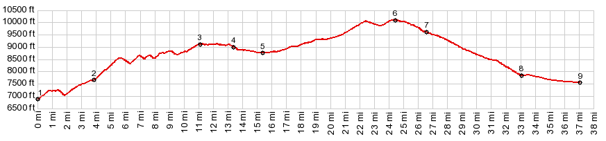
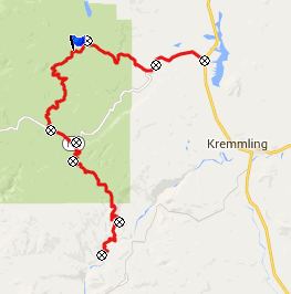
FR250 Rock Creek s(u)
The Gore Range has two different
faces. One face is that of Mount Powell and
Eagle's Nest Peak, two great peaks most people
think of when they hear the name "Gore Range". But
a much larger area of the Gore Range looks more
like the Adirondacks of New York for example,
assuming that the pine beetle has devastated that
area to the same extend. Much of the northern part
of the range are tree covered rounded hills,
especially the area around Gore Pass. That being
said, this is actually the only road in that area,
that still allows for a few far views from the
summit, to remind you of the fact that this is
Colorado.
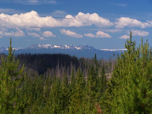
FR250 diverts from the Gore Pass Road in a large flat meadow section, a few hundred feet below its summit. The turnoff is signed. The road climbs through a small shallow valley, surrounded by pine beetle territory. Approaching the top, there are views reaching to Mount Powell to the north and the Flattops to the east. From East. After a
pleasant roll through the forest, descending a few
hundred feet, the road meets FR100. Turning left
here allows staying at this high, still relatively
cool altitude all the way to Rabbit Ears Pass.
But the profile takes the direct way down, turning
right. This road is a little more gravelly than
the other side. 500ft above the jct with the Gore
Pass Rd, the trees give way and reveal a drier
badrock landscape with interspersed houses
Dayride with this point as highest summit ( < FR212
Radium - Tonopas(sh) | Co134
Tonopas s(u) > ) |
|
|
advertisement |
|
|
advertisement |