| |
| |
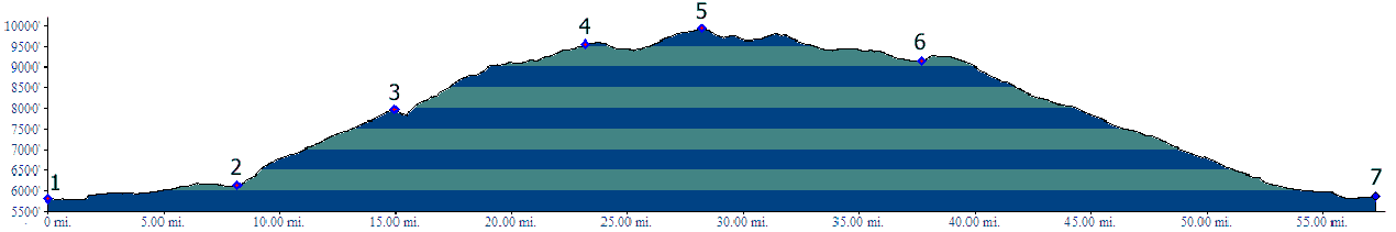
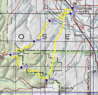
FR402 South Divide Road s(u)
FR402 runs roughly along the
crest of the Uncompahgre Plateau. The part, that
lies south of the most direct approach from
Montrose on CR90, is labeled South Divide Road on
many maps. The highest and longest part of the
Divide Road lies north of CR90. But the southern
part of the road has its own summit and the closer
views of the Sneffels group in the San Juan
Mountains.
From North. The approach from Montrose up to the jct with South Divide Road is described in the Divide Road s(u) page. South Divide Road turns off CR90 and at first it seems that the road does all it can to avoid getting close to the edge of the plateau. Meanwhile the level top of the plateau is getting ever narrower in this direction. Much of the forest next to the road has been
logged in an attempt to fight the pine beetle. But
there are still enough trees left, so that you
never get an idea just how close to the edge of
the plateau the road finally gets. Even though you
don't see it, the drop off to the valleys below is
never far away. To accomplish this the road winds
around quite a bit, always maintaining an
impeccably smooth surface without washboard (at
least duing my visit during the fall of 11). The
point of highest altitude has no views, and you
really would have no idea you're on it, unless you
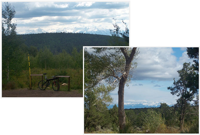
have been watching the altimeter. From South. (described downwards). There
is however a nice viewpoint of the Mount Sneffels
group and the entire range a short distance after
the top. The second group of pictures show the
first snow of the summer of 2011 on it. The road
rolls along, gradually loosing altitude, and the
range makes more frequent appearances in the
distant views, but ever drawing closer. At the
junction with FR510, one can head for Norwood or,
as the profile does, back to Montrose. Here this
dirt road is even wider, and has rare patches of
washboard surface, but still much less than
average. Much of the lower part into Montrose is
paved. Dayrides. PARTIALLY PAVED / UNPAVEDFR402 South Divide Road s(u) : lower part of Cr90, west of Montrose > up CR90 > south on FR402 > FR402 South Divide Road s(u) > east on FR510 Dave Wood Road > about 25 miles around Montrose > back to starting point: 79.8miles with 5560ft of climbing in 6:31hours (VDO MC1.0 m3:11.9.18).
first snow of 2011 in the San Juan Mountains, as seen from the Uncompaghre Plateau |
 Approaches
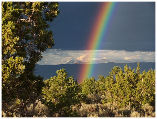
|
|
advertisement |
|
|
advertisement |