| |
| |
FR579 Cascade Divide Rd(ow) This may be a good access
route to reach the Colorado Trail a few
miles east of Bolam Pass - for somebody
willing to walk the bike a lot, and deal
with lots of downed timber over a very
short distance. As for me - I was content
to turn around at the end of the double
track. And so I am going to write this up
as a out-and-back summit - and a very
scenic route it is. Looking at the bright
side, going back down Cascade Divide Rd is
about 1000 times as scenically
interesting, than going down the shorter
east side of Bolam
Pass, which would have been the
decent from the Colorado Trail summit
point. Turning in the other direction on
the Colorado Trail would be a hard workout
over Rolling
Mountain Pass.
The excellent dirt road, which
will make a lightning fast decent, lasts to
about 10500ft. Curiously, where the surface
deteriorates into a rocky jeep road, the
interesting scenery starts too. Now
traversing along the hillside, the road
skirts along below several 12000 ft peaks on
one side, and an ever changing view of
Engineer Mtn on the other. Small rocky
descents lead to intermediate low points at
stream crossings. Finally the road makes one
last push upwards, and a last series of
switchbacks lead to a trailhead. According
to the map the Colorado Trail is not far
from here. But during my last visit much
downed timber made progress extremely slow
and difficult.
Dayride without two way
summits and this point as highest one-way
summit:
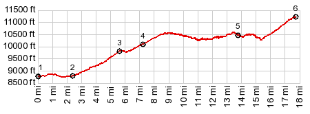
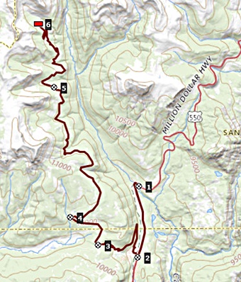
( < FR578 Hermosa Park Rd s(u) | Red Mountain No3 Road s(u) > ) Cascade Divide Rd(ow) : :near jct FR591 - US550, north of Purgatory Ski area <> US550 south <> Purgatory Ski area <> up FR578 <> up FR579 <> turnaround point at end of road and beginning of trail: 37.8miles with 4370ft of climbing in 5:50hrs (garmin etrex30 m5:21.6.30). 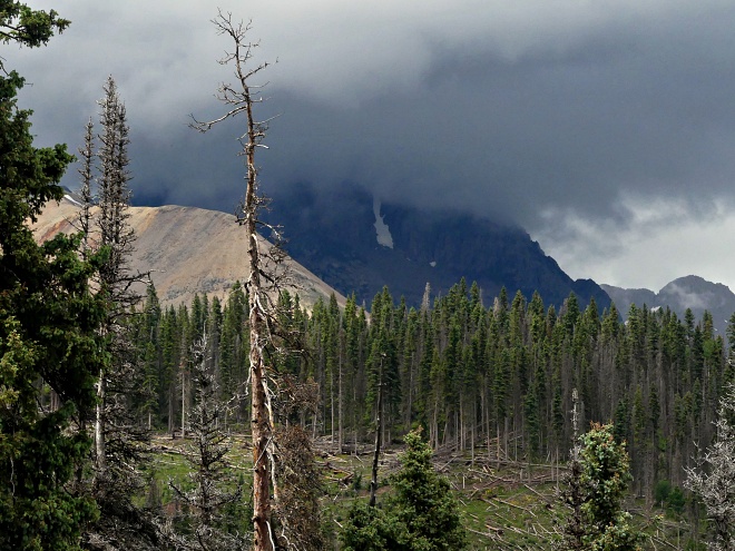 |
|
|
advertisement |
|
|
advertisement |