| |
| |
French Pass Four named passes cross Hoosier
Ridge south of Breckenridge. Of these French Pass
is the highest by a margin of 500 feet. It is also
the least traveled and the only single track
option of the four. It is arguably also the most
scenic. The upper right part of the profile is an
approximation, since that part of the trail is
very faint not marked on topographic maps, that I
had access to at the time.
From North. The profile begins at the junction of French Gulch and Rte 9 on the north end of Breckenridge. Past the Lincoln mine the French Gulch road becomes a double track, soon after a single track. For the last miles below the top, a very faint trail heads over expansive alpine meadows. The most rugged mountain faces along the journey wait just on the other side of the pass From South. (also described upwards) The
part of the profile between the start at Jefferson
and the French Creek road turnoff is shared with
the Georgia Pass
profile. A jeep trail follows several miles
up French Creek. Above that, a at times
intermittent trail connects with the top of the
pass. While traveling down this side and loosing
the trail, one option is to stay quite a ways
above French Creek on its east side, then head for
the dirt road as soon as it becomes visible from
above. (That's what I ended up doing on my ride). 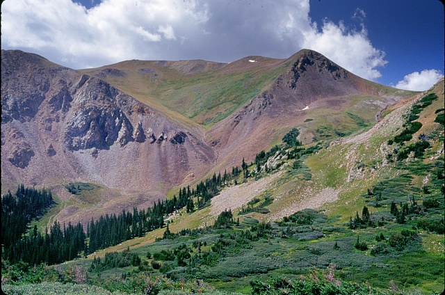
History
By the summer of 1860 the Colorado Gold Rush was on the large chain ring. On both sides of Loveland Pass miners were busy seeking gold, without ever crossing over the pass. From the many gold camps dotting the mountains around South Park two passes to the Breckenridge area had already been pioneered by miners. But that wasn't enough. From Breckenridge a few
seekers searched for the sake of searching and
ascended French Pass from the south. On the north
side they found a steep descent, until the valley
joined the Georgia
Pass route. By the next year, at least a few
wagons managed to make a southbound crossing. Yet
in retrospect this high pass never carried the
amount of traffic that its close lower neighbor, Hoosier Pass, did.
But Hoosier Pass was pioneered later by gold
seekers. 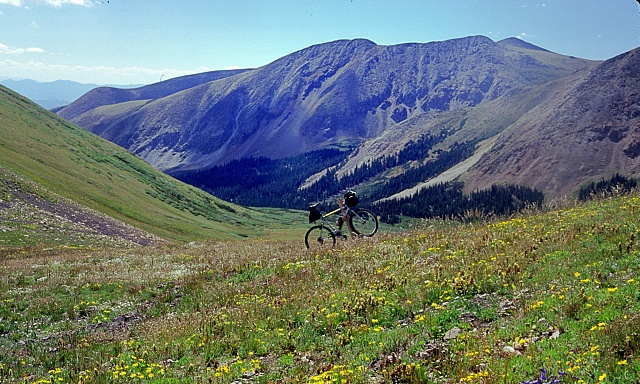 Dayride with this point as
highest summit:
-
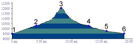
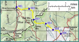
PARTIALLY PAVED / UNPAVED / SINGLE TRACK French Pass , Boreas Pass: Dirt road over Boreas Pass combined with the French Pass. The whole loop contains about 10 miles of hard top along route 285. This measured 67 miles with 4700ft of climbing in 6:7 hours (m2:98.08.23 dt42_26-30). This included a lot of time searching for a lost trail. |
 Approaches
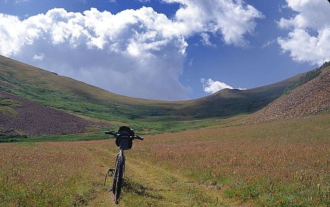 Colorado
Gold Rush of 1859/60 (
Colorado
Gold Rush of 1859/60 (|
|
advertisement |
|
|
advertisement |