| |
| |
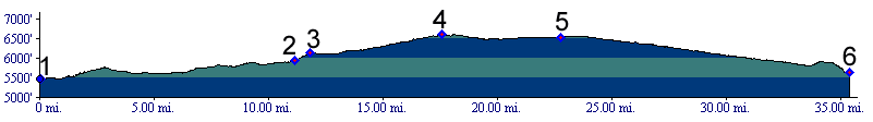
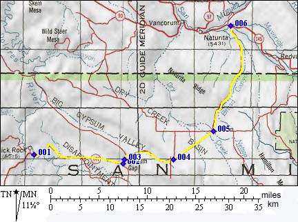
Gypsum Pass s(u) Gypsum Pass is a topographic
anomaly on the Colorado Plateau. Drainages in
this area already existed before the enormous
geological uplift in this area occurred.
Established rivers carved valleys into canyons
through the soft rock as the uplift occurred. As
the drainages were modified, some canyons
captured other rivers, leaving these canyons
high and dry.
In this environment it is not surprising that Gypsum Pass, a true water divide, is anything but a topographic high point. Instead it is an interesting example of Colorado Plateau peculiarities. The pass is often marked as Gypsum Gap. This includes the deLorme Gazetteer, older highway maps published by the Colorado tourist board and topo maps. But it is a true water divide, and the Colorado Tourist Board's 2005 map identifies it as Gypsum Pass. Helmuth's book "Passes of Colorado" identifies the pass as a water divide between Disappointment Creek and Gypsum Creek, but keeps its name as "Gypsum Gap". Traffic along the entire route is sparse.
From South. A few initial curves
extricate the road through an easy exit from
Dolores Canyon. Then the road rolls over shallow
dessert hills in a straight line towards a low
hogback ridge. A slight gain in elevation
can be noticed on a bicycle. But the only evidence
is the improving view of the La Sal Mountains in
Utah, which slowly creep above the valley horizon.
The triangular peak to the right of the road is
not some obscure dessert butte in Disappointment
Valley but Lone Cone Peak, western most sentinel
of the San Juan Mountains. After reaching the
crest of the low hogback ridge, which is Gypsum
Pass, the road continues to climb in this new
watershed in order to reach it highest elevation
at a point dividing Dry Creek Basin and Big Gypsum
Valley. The real summit along the road is actually
also a water divide, but not a named one. It
divides Dry Creek Basin from the Big Gypsum Creek
drainage. Dry Creek Basin is a closed basin,
ie. precipitation evaporates inside the watershed.
This makes the real summit a more unusual divide
than the named pass. From North. (described downwards).
The road drops straight as an arrow into Basin,
which is a name on a map for a sometimes open
store with informative BLM signage. The tablet
explains the special nature of this watershed.
Amazingly the highest parts of the drainage
receive over 30 inches annual precipitation, which
in other localities is enough to support downright
jungle like forests. Take the of northern part of
New York state for instance, which gets roughly
the same amount. But here in Dry Creek Basin all
of this moisture is evaporated by the sun, however
not before doing its utmost to erode the
watershed, much to the displeasure of the ranchers
in this area. The rest of the sign forest
describes their efforts to deter nature from this
feat. 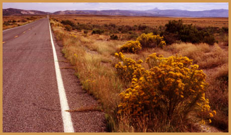 History Escalante (<Hesperus
Pass|Columbine
Pass>). The low mesas surrounding Gypsum
Gap don't force the overland traveler to stay in
the valleys. Instead the flat topped mesas are
tempting goals to climb, so that one might get a
better overview of this complicated maze and catch
a better view of the La Sal Mountains gleaming to
the north. In this light it is logical that the
Dominquez Escalante expedition of 1776 did not
cross Gypsum Gap, but near it. But their motives were very different than those
of a hiker, biker or a modern landscape
photographer. After all their mission was to blaze
a trail to the Spanish missions of Monterey, not
leave a 2000 mile trail through the maze of
southwestern canyons, which today is memorialized
by innumerable signs saying in effect: "Escalante
slept here". A reconstruction of the route by
Walter Briggs in "Without Noise of Arms" has the
expedition pass through the eastern starting point
of the profile, the Slick Rock Bridge area.
Wanting to adhere to their westerly course to
California they proceeded not along today's Co141,
but up the Dolores. After finding further progress up McIntire Canyon
and the Dolores Canyon upstream from Big Gypsum
Valley impassable, they were faced with the
difficult decision weather to change their
direction of travel. Since every padre and Indian
guide had a different opinion on how to proceed,
they again did what was logical, leave the matter
to chance, or in their case religion. They cast
lots, trusting that God in the form of lady luck
would tell them the best course. Their diary does
not mention in what form they did this, weather
they threw stones on the ground, or played a game
of luck. God told them to follow the lay of the land which
also conveniently contained a good trail. This was
Big Gypsum Valley. Unfortunately it headed in
exactly the opposite direction, south east.
Escalante's diary puts the course at north east.
This is just one reason why the reconstruction of
the route can be challenged. On the other hand,
being off course is a characteristic of the
Escalante expedition. After all, who else passes
over Gypsum Pass on their way from New Mexico to
California ? Still, their cartographer Miera was annoyed to
the point, that he persuaded the party to climb
the mesa ridge to the north, causing much
grumbling and hardship in the group. In this way
the expedition crossed slightly north of the the
high point on the Gypsum Pass route into Dry Creek
Basin. As for Gypsum Pass itself ( located below
the high point ), it was circumnavigated with a
four day detour to the north. All that became
apparent to our intrepid travelers on top of this
mesa ridge, that is bleak to the point of being
fascinating. Then they descended into Dry Creek
Basin. The nearest spot on the highway is marked
by a sign saying in effect "Escalante slept near
here". From here the group was able to travel north west
again, but only for a short distance, by following
Dry Creek upstream and following roughly the route
of EE21rd over an unnamed summit descending
into Paradox Valley. There is no evidence in the
Escalante journals, why at this point they did not
follow the Paradox Valley north west towards
today's Uravan, their preferred direction of
travel. One has to assume that Indian guides and
perhaps the view of a wide valley becoming ever
deeper heading towards a major mountain range,
filled them with suspicion of ever deeper canyons
and hard travel in that direction. Instead the reconstruction of the route has them
crossing Paradox Valley and then Sawtooth Ridge in
order to descend to the next major river, playing
a paramount role in the Escalante journals, the
San Pedro. Today's maps label this river as the
San Miguel. From Indian guides they knew that
their San Pedro joined waters with the river that
had the most influence on their wandering lives so
far, the Dolores. The location was presumably near
a range that they called the "sierra de la Sal",
the range of Salt, named after salt obtained there
by Ute Indians. Upstream they presumed the San
Pedro and San Miguel to originate in the Sierra de
las Grullas, the range of the cranes. Unlike the
name "la Sal Mountains", the mysterious
designation Crane Mountains has not survived.
However they were correct in their assumption that
this river originated in a mountain complex that
had the importance of a continental backbone. They elected to follow the San Miguel upstream,
south east. This was the wrong direction towards
their goal. Downstream would have brought them
towards their goal, California. They chose to head
for the promise of mountains instead of the thread
of wandering a canyon maze again. This lead them
onto the Uncompahgre Plateau, where at least one
speculation has them crossing Columbine Pass. A Dayride with this point as intermediate
summit is on page: Lone Cone SWA
s(u)
|
||||||||||||||||||||||||||||||||||||||||||||||||||||
 Approaches
|
|
advertisement |
|
|
advertisement |