| |
| |
Hardscrabble Saddle
Hardscrabble Pass is a crossing
in low forested mountains north west of the
Sawatch Range. Both approaches lead from light
colored badland hills into forested mountains. The
approach from the west is quite obvious and open
to motorized traffic, even when I didn't meet any
at all during my last traversal of the route on a
weekday. The surface is generally very smooth and
extremely bikable during dry weather. In contrast
the approach from the east offers many approach
options, including unsigned single tracks with
several confusing junctions and access points. The
route is more easily identified in a downward
direction. The saddle is marked on National Forest
maps and included in Helmuths' book "passes of
Colorado".
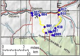
From West. The profile starts in Gypsum,
turns up Valley road ( same as Cottonwood Pass ),
the turns onto Cooley Mesa Road towards the Eagle
airport. At the airport Spring Gulch Road turns
south. It turns to a very rolling but smooth dirt
track traversing a trashed BLM area that has been
restricted because of people who can't hold their
Coors Light, which is probably why they drink
Coors Light in the first place. There are many
forks in this lower area and most of them just
converge back to the main route. The one or two
that don't can be eliminated by a little sense of
direction and riding down them for a couple of
hundred yards. The pass is in the direction of the
power lines that disappear on the mountain. The
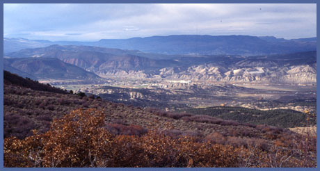
route climbs high above the valley and affords
good views of the unique light colored soft rock
outcrops south of Gypsum. The track traverses back
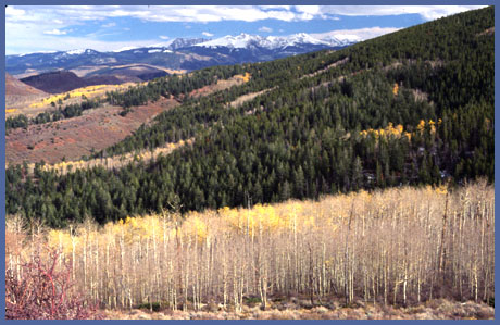
around the west side of the gentle but big
forested Hardscrabble Mountain ahead and finally
climbs straight for the gap separating the
drainage to the east. Several double track trails
diverge immediately before the pass and at its
top. All of them lead to points with a higher
altitude than this pass. The description follows
the double track trail that seems to cross the
pass and decend the other side. It is signed as a
dead end trail open to motor vehicles. After a
short decent it becomes an easily ridable forested
single track trail that forks after a stream
crossing in a small meadow. The trail to the left
following the stream more closely eventually ends
in a tangle of woods, in spite of the fact that
topo maps show it decending directly into Abrams
Gulch. The right fork climbs over the next ridge
where it reaches its highest altitude and then
joins a double track trail at a spot with a great
view on the Sawatch Range. The spot where this narrow steep single track
joins the double track is difficult to recognize
from the other side. Riding up from the east, it
is located right after a straight steady climb in
a long meadow. The double track makes an abrupt 90
deigree turn to the left and a metal stake marks
the take off point of the single track trail. At
exactly this point the first far view of the
Wasatch Range is visible roughly behind.
From East. The approach is described in a
downward direction. At this point it may seem like
all the work is over. But there still is
more rough stuff ahead. After a short decent back
into the forest the rider is forced to choose
between another fork. Both forks cross gates. The
description follows the left fork. The decent now
becomes a little rockier and leads to yet another
fork. The route to Gypsum goes downhill to the
right on a trail signed as being closed to
motorized traffic after a few miles. It then
becomes a single track that cruises straight into
Gypsum to the end of Abram's Gulch Drive. Even
though this is a public access point it is
necessary to lift the bike over a fence at this
point, and voila you are now in the middle of
suburbia in the mountains.
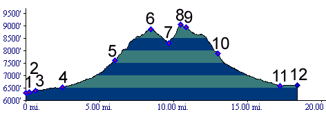
Tours Dayrides. A ride from Dotsero, approaching the pass via
Gypsum, descending to Eagle and retuning to
Dotsero on paved US6 measuered 41 miles with
4520ft of climbing in 4.52 hours, using an onboard
cyclometer with altimeter (m3:06.08.26). This also
includes following the dead end, mentioned in the
western approach section to its end, plus a few
other minor wrong turns.
|
 Approaches
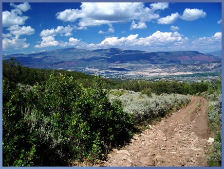
|
|
advertisement |
|
|
advertisement |