| |
| |
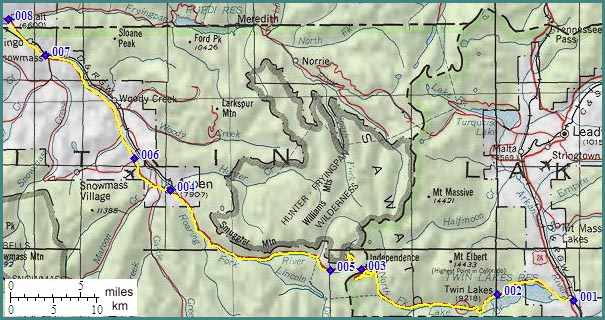
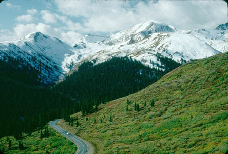
Independence Pass
The Sawatch Range south of
Leadville appears like a massive bulk of gigantic
proportions. This range is often said to contain
the highest paved approach of any Colorado pass,
the 4600 feet climb from Aspen to Independence
Pass. Here are a few alternative points of view:
the Trail
Ridge Road passes, Grand Mesa
summit(u). Whichever pass has the highest
climb, Independence Pass offers one of the state's
most extensive above treeline paved cycling
experiences, second only to Trail Ridge road and
the Mount Evans road.
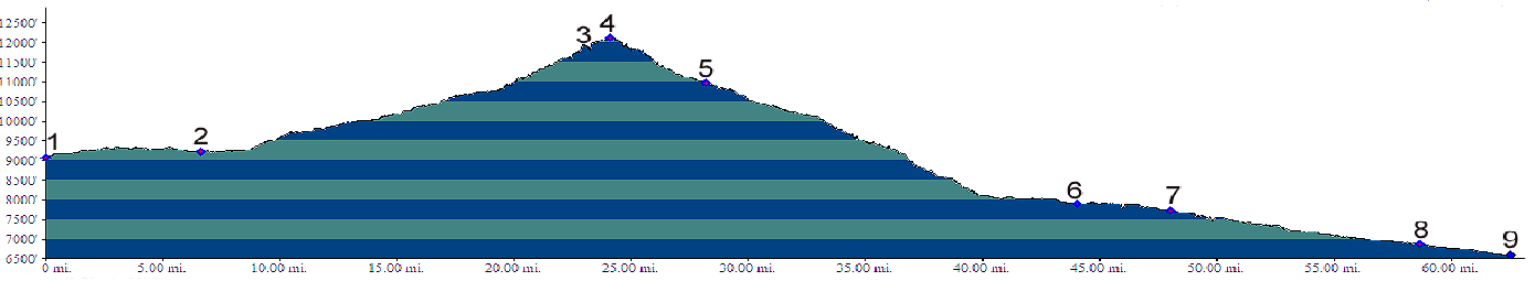
 Approaches From West. The profile starts in Basalt to
show that there is some climbing involved while
cycling the Roaring Fork Valley to Aspen. The
profile shows the most direct route on the
Highway. This involves a spacious shoulder on a
busy highway for the first few miles and then a
bikepath on the north side of the road. A longer
alternative that also invovles more up and
down is the Rio Grande Trail on the north
side of the Roaring Fork River. It is most easily
accessed from Basalt or point 7 on the profile,
the turnoff to Snowmass. Soon after leaving Aspen with a steep,
steady climb follows the upper Roaring Fork River.
Still below treeline, the road passes a very
narrow section with overhanging rocks on one side,
and an intermittent stone wall on the other,
marking the precipice to the tumbling mountain
stream below. This section contains places that
are too narrow for two cars side by side, much
less two cars and a bicycle. However traffic speed
is limited to 10mph and tends to be considerate,
and with a little attention to surroundings,
perfectly safe. As the road nears treeline, the
landscape takes on a grandiose scale and the road
sweeps above treeline with a few far flung
contours.
From East. (also described upwards) The
profile starts at the junction of the Independence
Pass road with US24 at Balltown. But coming up
from Buena Vista, you can't help but notice that
its been basically uphill for a long time. No
wonder - the road follows the Arkansas River
upstream, and all those rapids need some slope to
develop. Many cycling groups that cross the pass and back
in a day start - or turn around - a few miles up
the road in the small settlement of Twin Lakes.
There cyclists also can stack up on fishing
supplies, they may or may not want to carry over
the pass. Soon after leaving the Twin Lakes, the
road passes between two 14000 foot giants. Mount
Elbert, Colorado's highest mountain, is to the
north and its top can't be seen from the road. But
La Plata peak to the south has been the
predominant backdrop to the Twin Lakes for several
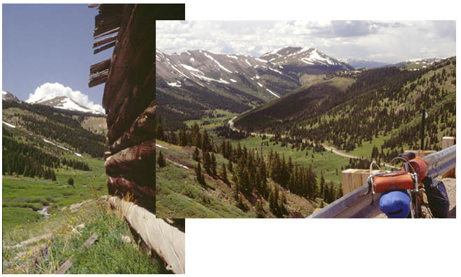
miles already. The road follows a large gentle curve of the
north fork of Lake Creek, heading north. It
finally breaks above treeline, amongst the
meanders of the creek, heading straight for Mount
Champion (13646ft). The wild, snake like meanders
of the North Fork of Lake Creek look especially
interesting after that first switchback is
negotiated and the road has gained a little
elevation above the valley. Next heading in a
westerly direction the road climbs into a sweeping
high tundra valley. Since rising above treeline
the road only needs four switchbacks and
connecting ramps to gain the last ridge. An
interesting stop, besides the top, is the ghost
town of Independence. Rides with this summit as highest point: A Day on a 15 Day Tour: COMPLETELY PAVED: (<Mc Lure Pass|Fremont Pass>) Dayride: PARTIALLY PAVED / UNPAVED (< Stoney
Pass | CR170 the
Pines Ranch(sh) >)
History The Leadville Boom (<Cottonwood
Pass|Taylor
Pass>): Independence Pass was the first
and last pass to supply the Aspen valley. But
there were others in between. It was a time when
gold and silver seemed to be everywhere. From
Leadville the boom had moved to Gunnison, Pitkin
and Tincup. A case of glittering rocks was
discovered far above Twin Lakes on July 4th 1879,
at least that's how the story goes. Attaching the
name "Independence" to the mine seemed like a
natural.. In 1880 business men took advantage of
the profit potential presenting itself and
improved a trail across the ridge so that horses
could use it, for a fee of course. That first year only pack animal trains could use
the road. But by 1881 wagons were crossing, taking
25 hours and five changes of horses from Leadville
to Aspen, which is quite a bit slower than the
same route today on a bicycle. Even while still
arranging the financing for the Independence Pass
road, competition already arose from
unlikely sources. The route to Aspen using Taylor Pass had the
advantage of being already constructed for the
most part, even though it was quite a bit longer.
Pearl Pass, the most
unlikely pass of them all, also had the biggest
attraction on its other side, a railhead from
which mining ore could be shipped out. But Independence Pass finally won the
competition. It was November 1881 when
Leadvillians decided that their toll road would
reign supreme over the Taylor
Pass and Pearl
Pass alternatives. 75 toll company men and
the entire town of Independence worked on road
improvements, attacking the pass from both sides.
When it was done, traffic from both competing
routes switched at once. Snow could not stop them.
They just switched to sleighs. Due to heavy
traffic, the following spring hairpin curves were
banked so that stages could descend full speed.
Specially trained dogs were sent ahead of the
stages to warn of oncoming traffic, making this
Colorado's first heavy traffic warning system. 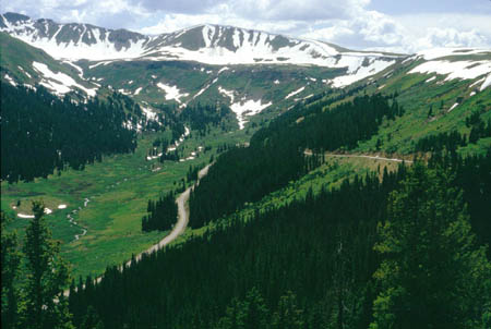 The toll road's heyday lasted till something
better came along. This happened in the form of a
railroad tunnel under the same mighty Sawatch
Range. Hagerman's Colorado Midland Railroad opened
a tunnel under a rough pass to the north, all
bearing Hagerman's name in 1887 and regular stage
coach traffic plummeted. Cycling - Ride the Rockies: (<Hoosier Pass|Juniper/ Squaw Pass>): The first pass ever crossed by the Denver Post's "Ride the Rockies" remains unrecrossed by the tour as of 2005. Between 1986 and sofar (2005) Independence Pass was on the schedule one time, on day 3 of the first tour in 86. The stage led from Aspen to Leadville. On the route from Grand Junction no passes were crossed previous to this pass and the route continued over Fremont Pass.
|
||||||||||||||||||||||||||||||||||||||||||||||||||||||||||||
|
|
advertisement |
|
|
advertisement |