| |
| |
Last Dollar Pass
 Last Dollar Pass came
into being as an intended shortcut to the Dallas
Divide between Telluride and Ridgway - allegedly.
Distance wise it may be a little shorter. But
regardiess of the mode of travel, timewise it is
longer. It just appears shorter because there is
so much to see. The route is identified as Last
Dollar Pass on a map of Telluride attractions that
is sometimes available for free locally. It is
also included in Helmuth's "passes of Colorado".
But the label "Last Dollar Road" is used on road
signs and is a more common designation. The entire
road is smooth dirt and extremely bikable when
dry, except for a very short stretch of deep rocks
halfways up the Telluride side, which helps to cut
down on motorized traffic. When wet, clay on the
Ridgway side makes part of the route extremely
slick and practically impassable. Last Dollar Pass came
into being as an intended shortcut to the Dallas
Divide between Telluride and Ridgway - allegedly.
Distance wise it may be a little shorter. But
regardiess of the mode of travel, timewise it is
longer. It just appears shorter because there is
so much to see. The route is identified as Last
Dollar Pass on a map of Telluride attractions that
is sometimes available for free locally. It is
also included in Helmuth's "passes of Colorado".
But the label "Last Dollar Road" is used on road
signs and is a more common designation. The entire
road is smooth dirt and extremely bikable when
dry, except for a very short stretch of deep rocks
halfways up the Telluride side, which helps to cut
down on motorized traffic. When wet, clay on the
Ridgway side makes part of the route extremely
slick and practically impassable.
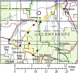
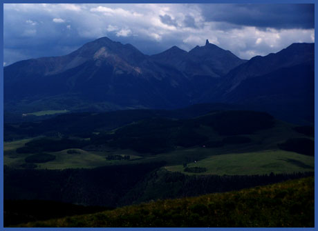
Approaches From North. Last Dollar road leaves in a south easterly direction from the highest point on 58.p road, described in these pages under Hastings Mesa summit(u). After a short climb the road descends to cross a creek and then climbs relentlessly through patches of aspen forest to the summit. The is the closest bikable road to the Sneffels group (but there are trails further up). But you never see the peaks. One viewpoint that can compensate for this is a vista stretching from Lone Cone Peak to the needle like Lizard Head Peak and the 140017 ft Wilson Mountain. Then it's back into the treetunnel to the summit. From South. The route is described in a
downward direction. While the northern approach is
a tree ride, the panoramas on the south side just
won't quit until you are basically at the bottom.
Lone Cone Peak is now out of the field of vision.
But instead the amphitheater of mountains behind
Telluride have been added to the repertoire. A
long sweeping curve on a grassy hillside leads
into a Telluride millionaire mansion district of
sorts, buildings far enough removed from the road
that nothing interesting or even vaguely
attractive about the area can be discerned, unless
monstrous address stone piles stir one's interest.
A fork offers a choice for the final descent,
Telluride or Deep Creek on Co145. The profile
follows the Deep Creek option.
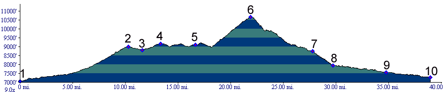
Dayrides with Last Dollar Pass as
highest summit: Last Dollar Pass , Hastings Mesa
s(u) : Ridgway > Dallas Divide(shp)
> Last Dollar Pass > down Deep Creek >
Sawpit > Hastings Mesa s(u) > 60 miles with
6730ft of climbing in 5.3 (Cateye 100AT m3:6.8.2). 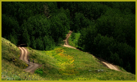 |
|
|
advertisement |
|
|
advertisement |