| |
| |
Muddy Pass
The word "park" has a second
meaning in the American west. It refers to a high
plateau - often a sage covered plain, ringed with
mountains on all sides, or at least on as many
sides as possible. Muddy Pass connects two such
parks. It seems like Middle Park and North Park
"flow up" in order to meet at this point. With
that Muddy Pass is the lowest continental divide
crossing in Colorado.
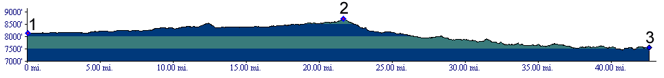
From North. This is the shallow side of a
shallow pass, and it barely climbs 600ft. But
still I think this is the best road cycling of the
entire Muddy - Rabbit Ears - Steamboat complex.
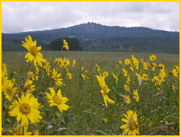
There is less traffic here and atl least on my
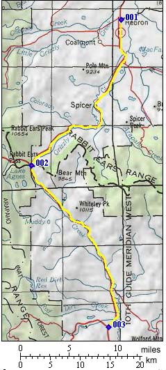
rides it seems to be more considerate. And the scenery ... is best at the bottom ... given the right conditions, which usually involves a spectacle of clouds, which again produces a spectacle of light, playing, reflecting and interacting with the distant mountain ranges. When the road reaches the turnoff to FR103
Indian Creek Road, Rabbit Ears Peak, sofar
only a insignificant blip on the horizon, moves
into the center field of view. From now on, that's
what the road is heading for. It serves as marker
in the landscape, like the label on a piece of
clothing, so that there is no identity crisis
during the entire approach. Muddy Pass lies
right below Rabbit Ears Peak. Watching the
altimeter, the digits change slowly. Before the
top the road actually seems to level out. The highest point is not marked. But it is the
intersection with all the traffic coming from
Steamboat Springs and Rabbit Ears Pass
(mostly on weekends) From South. (also described upwards).
It's tough to designate a starting point on
this side. So I started the profile back at the
jct with the turnoff to Gore
Pass. As Middle Park gently rises up towards
this pass, its character takes on a sage valley
character. The hills are dotted with waves of
hills terminating in nipples of all sizes. One
landmark along this section is a medium sized
triangular mountain, Whiteley Peak (10115ft)
fronted by wooden ranch buildings. The last few
miles seem to be heading for Rabbit Ears Peak,
within a range of plus/minus 20 degrees. On the
right there is a "ghost town" for sale, or at
least a good replica of one. It has been on sale
for a long time, and the market in dilapidated
wooden shacks seems to be very soft, even this
close to Steamboat Springs The very last stretch
of road on this side seems is steepest section of
this road. During weekend commuting season this road can
have a lot of Steamboat Yahoo traffic. There is no
shoulder wide enough to ride on. The lower part is
rumble stripped in the middle, but undamaged on
the side. The top remains blissfully unrumbled -
something we have to be thankful for in the United
States, which is taken for granted in the rest of
the world. Dayrides with this point as intermediate
summit are on page: A Day on a Three Day Tour with this point as
shoulder point is on page: Rabbit Ears Pass
 History Fremont ( <FR543
South Spring Creek Rd s(u)(Wy) | Hoosier Pass>)
: In the summer of 1844 the catch phrase "manifest
destiny" was gathering steam. America was destined
to become a continental world power. For that it
needed Indian and the Spanish territory of Texas,
California and today's New Mexico. The Missourian
senator Hart Benton did all he could to further
exploration and settlement along the nation's main
people pipeline heading west, the Oregon trail.
And what better person to put in charge of a
military expedition to map the area than your son
in law ? His son in law, lieutenant Fremont, roamed the
west in search of military and emigrant routes, in
charge of three dozen or so men who weren't
exactly regular army issue, but a collection of
trappers, traders and guides. Over time they
included a Taos guide named Lucien Maxwell, who
was about to marry into a Taos family. This family
had recieved a large landgrant in the Sangre de
Cristo Mountains. That was the Spanish version of
encouraging settlement; give more land to the
rich. One of Fremont's expeditions also included a
young William Gilpin, who would become a future
governor of Colorado. Fremont had a deep desire to explore the granite
heart of the Colorado Rockies for routes and
passes. But his main area of activity had centered
around South Pass and the Oregon Trail. It was not
until his second expedition in 1844, that he
penetrated the mountains south of extreme northern
Colorado. From the eastern side of Wyoming's Battle Lake
Pass he headed south in North Park, until
they happened upon Muddy Pass. His reaction was
quite ecstatic and is in contrast to how we may
see this low divide today. "A beautiful valley of
thirty miles diameter" ... "walled in all around
by snowy mountains" ... "we crossed the summit of
the Rocky Mountains through a pass which was one
of the most beautiful we had ever seen". These
observations describe the beauty of North Park in
factual simplicity and are less directed at the
pass itself.. Maybe the statement was also a
consequence of three days of excellent crystal
clear spring sunshine, after a winter of death and
hardship for the expedition. A clear sunny day
riding over Muddy Pass is better than getting
nailed by a thunderstorm on Trail Ridge Road. 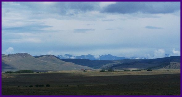 Hayden Survey (<Ute
Pass|Willow
Creek Pass>): The Hayden survey was to US
geographical surveys what the Escalante expedition
was to Spanish missionary expeditions. They
accomplished more with less. Hayden's groups
traveled in groups of 6 to 8, a topographer and
his assistant, a geologist or two, packers and a
cook. The majority of them was less than 30 years
old, and they were absorbed in the scientific and
visual marvels they discovered. They had no use
for canons and guns like the military expeditions
that preceded them. Instead they used mules, which
made them seem harmless to the Utes. They took
along as little equipment as possible. The
exception was the official photographer of the
group, Henry Jackson. His huge camera had to go
everywhere, and the tent dark room had to be in
quick reach. We can still admire the fruits of all
that effort and artistic talent in many museums. The Hayden Survey did the definitive mapping work
in Colorado. Little has been added since then.
They spent the summers and falls of 1873, 74 and
75 roaming the passes, climbing the mountains, and
making notes and conclusions of every kind. During
their free time they were based in comfortable
civilized "little London", as Colorado Springs was
known at the time. During their first year in 1873 a crew of the
Hayden survey, headed by 25 year old topographer
Marvine, mapped three passes between Middle and
South Park : Muddy pass, Willow Creek Pass,
and Troublesome Pass. The two lower routes are
major highways today. Muddy is the lowest and in
the minds of some, the most unremarkable of all of
them. But it was remarkable to the speculating
mind of S.B. Ladd, assistant to Marvine. He
speculated about the consequences, if Muddy Pass
would be a little lower still. If Middle Park had turned out 800 feet higher at Gore Canyon, and if the already low Muddy Pass had been yet another 800 feet lower too, the Colorado river would have turned north near Kremmling to join the North Platte. This waterway would have been a huge eastern river, combining forces with the North Platte to rival the Mississippi in volume, making Wyoming a corn and hog state. The North Platte could have been a traffic route along which tourists could travel in steamers towards the Rockies.- So much for what might have been.
|
||||||||||||||||||||||||||||||||||||||||||||
 Approaches
|
|
advertisement |
|
|
advertisement |