| |
| |
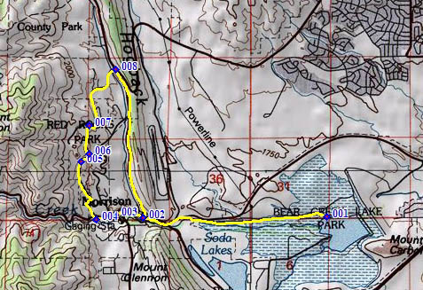
Red Rocks Park - Trading Post
Rd(sh)
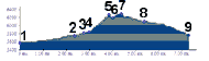
This little shoulder summit is
easily the scenic high point on a ride around
Denver. It is crossed when following around the
outside western perimeter of Red Rocks Park. It is
located at the signed intersection: Trading Post
Road - West Alameda Parkway. The profiled route
follows the soutwestern most entrance to Red Rocks
Park. Along the way on the south side there is a
very small, but steep and beautiful climb between
the rock monuments of the park.
From South. In order to start from a low point, the profile starts at a picnic area on the north east shore of Bear Creek Reservoir. From there the profile picks up the often cycled, low traffic road inside the park to Morrison. It then turns right at the Titan Road entrance to the park. Soon there is choice to remain on
Titan Rd on the left or turn onto Red Rocks Park
Rd on the right. The profile follows the left
fork. A few miniature switchbacks quickly climb up
towards the amphitheater entrance. This feels like
a summit at first. But after the next left turn
onto Trading Post Road, the profile goes just a
few feet higher. The highest point is at the jct
with Red Rocks Loop Rd. From here it's a short out
and back climb to the top entrance of the
amphitheater, not to be missed on a first ride
over this loop.
From North. (described
downwards). A short downhill roll ends abruptly at
the junction with Co8. The profile turns
right and just goes back down to Morrison. But the
best way to continue after this small summit is to
cross Co8 and ride over Dinosaur Ridge. That point
is lower than the Red Rocks Park summit point.
Even when turning left east of Dinosaur Ridge, and
then crossing Rooney Road(sh), the Red Rocks Park
shoulder summit stays the highest point, and
Rooney Rd(sh) is just a shoulder point, ie the
climb from the east side of Dinosaur Ridge to
Rooney Rd(sh) is less than 300ft.
|
 Approaches
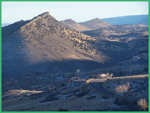
|
|
advertisement |
|
|
advertisement |