| |
| |
Stillwater Pass
This pass is a prime viewpoint
on the Front Range - from the back. It crosses
forested hills that reach south from the Rabbit
Ears Range. An expansive forest fire has
transformed the character of this area since my
first ride over the pass, now giving many open
views on the east side.
From West. The profile includes the paved
approach up the road to Willow Creek Pass. This is
very pleasant paved ride with very little traffic
-in contrast to the next drainaged= to the east
and the Grand Lake area. The turnoff oto Stillwater Pass Rd is signed.
This is a fairly wide road with hard compressed
dirt that is perfect for what is being called
gravel biking, even if this compressed dirt is
much better than loose "gravel". Ironically
Stillwater Pass Road now follows Willow Creek,
while Co125 Willow Creek Pass Rd has now lost its
meandering companion and is streamless. The road
heads east towards supersized rounded mole hills,
that crack the 12000ft scale in the Never Summer
Mountains: Ruby Mountain and Cascade Mountain. As
the course of the road winds around to the south,
evidence of water across the road becomes more
frequent. At point 5new/6, at the junction with another
supr road, the character of the climb changes. For
one thing, the road is closed to motorized traffic
from here on (Aug/23). The surface is a lot less
compacted and consequently progress becomes
sporadically very slow, especially if it rained
last night. Also the road remains in thick forest
now, even if it is thick matchstick forest in
these decades after the last big forest fire. The
top is also in surrounded by reemerging growth. A
spur to the north does not get to any immediate
view points 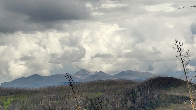 From East. (described downwards).
Immediatel after the top there is an intersection,
that can be confusing if one is in a hurry and
reluctant to look around. The fork in the road
points to the right option with the label
"Stillwater Pass Rd, Gravel Mtn AWD road". However
- Stillwater Pass Rd continues to the left of the
fork. The Stillwater Pass option on the right is
meant to signify that you have an option to rejoin
it if you go for the Gravel Mountain option. A
sign facing the other direction makes that clear. The best part of the ride comes a short distance
after that. The surface improves somewhat. But the
best part is the nearly unobstructed view, lasting
for several miles to the backside of the Front
Range. The Indian Peaks and the mountains in Rocky
Mountain National Park present a steep crowning
wall of cliffs in the distance, set on top of high
rolling hills that ring them like a belt. In
between here and there is the enormous expanse of
sticks left by the huge forest fire. The roll down has a very unconsolidated surface
in many places, and approaches Grand Lake through
a variety of vantage points. During my last ride
the road was closed to all motorized traffic from
a designated "staging area for ATVs". From here,
all that is left is a few rollers on pavement
through Grand Lake vacation housing. This forest
road joins US34 at the north end of the lake.
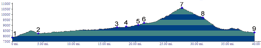
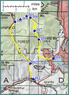
Dayrides with this point as highest summit: PARTIALLY PAVED / UNPAVED ( < Kaufman
Creek Rd s(u) | Green Mountain
Road s(u) > ) Stillwater Pass: jct FR108.1 Buffalo
Creek Rd - Co123 > Co125 north > FR123
Stillwater Pass Rd east > Stilwater Pass
<> short out and back on Gravel Mtn Rd with
turnaround point where it becomes very narrow
>> US34 south > western outskirts
of Granby > US40 west > Co123 north back to
starting point: 52.4miles with 2870ft of climbing
in 5:54hrs (garmin etrex32 m5:32.08.27). -----------------no elevation
measured------------------------ Stillwater Pass, Willow Creek Pass
x2: near jct FR50 - Co125 > Co125 south
> Willow Creek Pass > Co123 > FR123
Stillwater Pass Rd east > US34 south > Grand
Lake area > Granby area > US40 west >
Co123 north > Willow Creek Pass > back to
the starting point at near jct FR50 - Co125:
71 miles (m1:93.07.23) (pics: dt_35_1101-1103,
dt_36_01). |
 Approaches
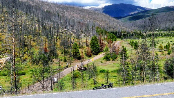
|
|
advertisement |
|
|
advertisement |