| |
| |
TR898 Shady Creek(sh)
The Shady Creek Trail in the Del
Norte area is open to small motorized vehicles,
hikers and mountain bikers. One might expect a
traffic jam under these regulations, but on my
traversal of the route, on a Saturday in June, I
met no other trail users on the TR898 portion of
the profile below. The trail contains nice bikable
stretches as well as plenty of walking stretches.
The summit portion is easily bikable, and dirt
roads can be used to lead around the walking
portions. Older maps (such as my Rio Grande
National Forest map from the 80s ) contain errors
and miss several dirt roads and trails. Even with
up to date maps, orientation can be a challenge
with so many roads and trails, and few straight
East-West, North-South landmarks, which Colorado
travelers are used to.
FR358 reaches a higher altitude than this trail, while traversing round Del Norte Peak. So this summit is a shoulder summit, and has a (sh) behind it.
From West. The turnoff from US160 onto
FR345 is signed as Del Norte Peak Road. During the
initial turns of the road, its namesake can be
seen ahead, framed by green trees blowing in the
wind. It is a rounded mountain with its real
proportions difficult to discern. The profile
above turns right onto FR350 at the first major
fork. But the left also offers alternative routes
to get to the summit. The dirt road leads through
a firewood area, then becomes a bit rockier, then
smoother, steeper then more shallow, all of which
is well ridable. The initial turnoff to TR898 is
signed. It appears to stay straight, while FR350
continues in a right turn. This portion of TR898
is rocky, and difficult if at all ridable. But
soon the bicycle pusher finds himself climbing up
an embankment to meet another dirt road FR358. The
elevation profile skips this portion of the trail,
staying on FR350, turning off directly onto FR358. The next portion of TR898 is a short distance
south (left turn) on FR358. The turnoff is signed
again, but once the road passes directly beneath
the face of Del Norte Peak, the turnoff was
missed. The elevation profile of this section is
only an approximation, since these roads and
trails are not on my topo maps. This is the summit
portion of the trail. It is shallow, easily
ridable, and pretty moist with late runoff. The
route stays in the trees. But immediately
following the summit an open meadow off to the
right side of the trail shows a wide drainage,
opening up towards the San Luis Valley and the
Sangre de Cristo Mountains shining in the
distance.
From East. (described downwards). The
trail crosses a gate and makes many turns, after
entering into a dense forest. A fairly steep
section next to the subalpine summit meadow soon
delivers the rider onto another dirt road, which
comes as a big surprise when you don't have up to
date maps. Apparently this is the original FR345
from the starting point. And if that is not enough
choices, there are also two single track trails
leading downhill Castle Rock Creek Trail, and
later merging back onto the trail described here,
TR898 Shady Creek.
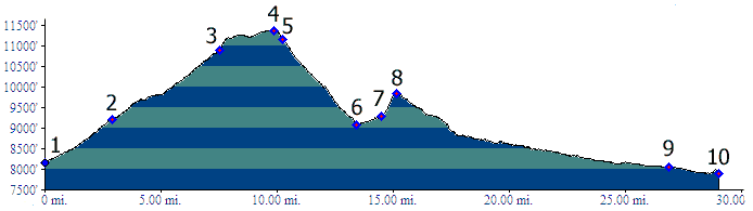
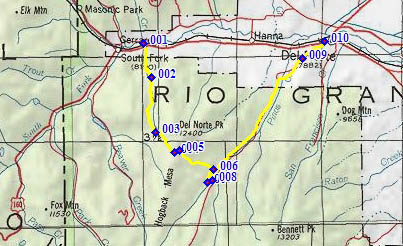
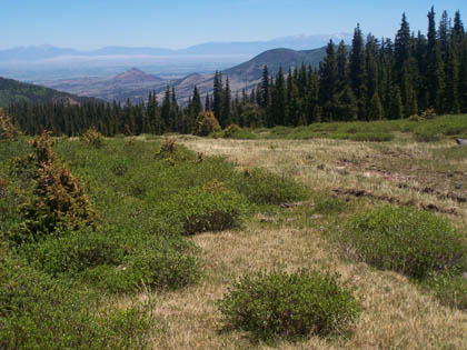
Picture locations: top to
bottom: 1: TR898 on west side after having crossed
FR345 while descending along Shady Creek. 2: view
of San Luis Valley from meadow adjacent to summit.
3. summit meadow Dayride with this point as highest summit
TR898 Shady Creek s(u): campsite on lower
portion of Del Norte Peak rd (FR345) > FR350
> initial turnoff onto TR898 > crossing
FR345 to pick up TR898 again > TR898 Shady
Creek s(u) > down TR898 Shady Creek > Pinos
Creek crossing > FR14 towards Del Norte >
FR14A west > US160 west > lower portion of
Del Norte Peak rd back to starting point: 51 miles
with 5200ft of climbing in 6:17 hours (VDO MC1.0
m3:10.6.20).
|
 Approaches
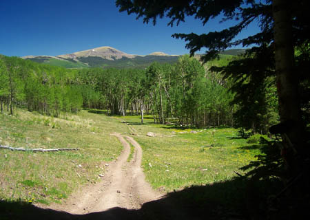
 Once Pinos Creek is reached, the
route turns upstream. This may come as a bad
surprise. But thank goodness, this late in the
day, the route does not head back into the
fathomless wilderness, but crosses Pinos Creek
after a while, only to climb back up the other
side. The trail now looks more heavily traveled
and the next section climbs quite steeply before
merging onto FR14 without prior visual notice.
Once Pinos Creek is reached, the
route turns upstream. This may come as a bad
surprise. But thank goodness, this late in the
day, the route does not head back into the
fathomless wilderness, but crosses Pinos Creek
after a while, only to climb back up the other
side. The trail now looks more heavily traveled
and the next section climbs quite steeply before
merging onto FR14 without prior visual notice.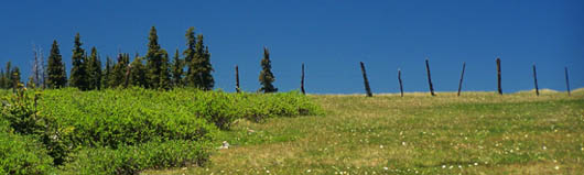
|
|
advertisement |
|
|
advertisement |