| |
| |
Alto de Aisa s(u)
Parts of the Spanish eastern
Pyrenees are the most remote part of this mountain
chain. This is one of the small passes between two
old villages, that retain their appearance from a
previous time.
The signed main road goes right through the
deserted town square and through a narrow alleyway
with medieval surroundings. No store is open, no
cars are parked anywhere. There is not a soul in
sight. This turns out to be the narrowest and most
remote of the narrow and remote little passes on
my route today. Climbing into the forested
amphitheater of wooded hills and looking back, you
have to look closely to locate Jasa surrounded by
all these forested hills. they reced behind the
town like waves in an ocean. The road appears to
turn to dirt - that's okay as long as it doesn't
end here. Actually a form of pavement returns
also. There are few remarkably steep and
interesting switchbacks at the well defined ridge
top.
From East. (described downwards). The
high Pyrenees come into sight at this point and I
take quite a few pictures. But the most sublime
spot is further down. After the computer with my
pictures was stolen, I did not think that I would
see images of this remote spot again. But -
surprise - this abandoned old stone building has
attracted other panoramio and flickr contributors,
and they had equally great light conditions as I
did. Downslope weather veils the far white ridge
in a soft, dark light, while the valley enjoys
clear sunshine. Some of the best pictures in the
slide show were taken in fall, while I was there
in the spring - and during that season trees
obviously behave differently. Since my pictures
were bicycle touring pictures, my bike also played
a more prominent role, together with the
undulating edge of the road, as wild vegetation
starts to erode its edges and makes it even more
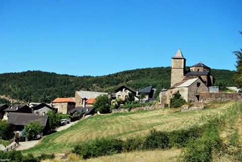
part of nature. Aisa is just a small group of old houses, grouped
around the church tower, equally closed down as
Jasa on the other side. But I do seem to remember
a closed hostal. The church tower also acts as
focal point for all scenes from further below. From Aisa there is actually another small pass
that leads over into the valley of the Rio Aragon.
But the profile descends the easy way to Jaca (as
I did also). It reaches a low point several km
before reaching this important waypoint on the
Camino de Santiago, while crossing a tributary of
the Rio Aragon.
|
|
|
advertisement |
|
|
advertisement |