| |
| |
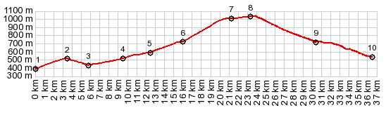
Col d'Aussieres
For many cyclists, this seems to be
the most popular of the passes in the area between
Prades and Axat. Maybe this is so, because a
famous old Cathar castle is along the way, and it
is on many obligatory tourist itineraries. Or is
it the fancyfull inspired canyon on the north
side? Or maybe it is just the completely
convincing peace of the pastoral nature of this
landscape.
I skipped the extra 2 km climb up to it, because
I was worried about actually making it back on
time for this loop. But I think I can see why it
is so obligatory. It must be a great view from up
there too. The fanciful canyon of the Aude ends
abruptly as the road climbs out of Salvezines. The
rest of the ride has a pastoral, peaceful
character of high gently wavy hills, through which
the road negotiates in a million turns. The Col
sign stands in a grazing area of sorts. But the
road gently leads a little higher, traversing an
ever so rounded long hill. The viewshed too
changes after the pass has been crossed
From South. The
character of the landscape stays the same. But
there is another town along the way, that really
grabbed my attention. The cluster of houses has a
pyramid shape. At the top reigns a church: Welcome
to Rabouillet. The town entrance signs offer two
different spellings. But on the way down, you
almost miss everything, unless you remember to
turn around after rolling through it. In Sournia the road reaches an intermediate low
point. But if you started out from Prades, or the
valley it sits in, Sournia is still a lot higher.
There are several possibilites of more passes and
summits for the return back to the valley.
A Dayride with this point as intemediate summit is on page: Col du Jau |
|
|
advertisement |
|
|
advertisement |