| |
| |
Col d'Azet
This is one of the stars of the
Pyrenean foothill passes. It belongs to the group
of passes that parallel the main ridge of the
Pyrenees as closely as possible on the French
side, even if this is at some distance. Other
passes that fit that description are Col de Peyresourde
and Col de Portet.
Col d'Azet sits right in a line between them. But
it doesn't have the heavy traffic of the former,
and both of its sides can be cycled unlike the
latter. This also seems to be a favorite spot for
people to stop and just have a pass-top-picnic. I
did too, but I do that a lot, so I don't count.
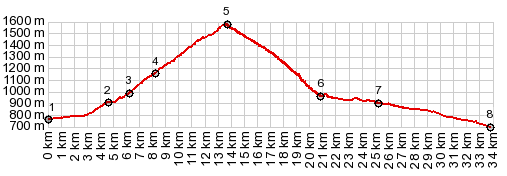
This beautiful little village too, finally
becomes nothing more than a collection of toy
buildings, when viewed from a handful of
switchbacks above. The pass ahead becomes obvious.
Behind it looms a white face of a mountain. The top is great perch: Col du Portet and
its mighty collection of walls on one side, Col de Peyresourde
cutting through a lower green loaf of a mountain
on the other. To the south a group of icy blocks
in the 2600 to 3000 meter range form a vague
boundary to Spain. Dirt tracks in each direction
invite to get an even better overview of the area.
From West. (described
downwards). Switchbacks connect together new
vantage points on the mountains to the south, and
finally reach Loudenville. A billboard at its
entrance advertises the fact that here calves are
being raised with their mother's milk. The town
makes a coherent impression of belonging to a
period, that started far in the past, but is still
persistently present. From here a new wider road
leads down direction Arreau. There are several
different options to connect with the next pass to
the east, Col de Peyresourde
Dayride with this point as highest summit: COMPLETELY PAVED ( < Col de Portet(ow) | Lac d'Aubert/d'Aumart(ow) > ) Col d'Azet , Hourquette d'Ancizan x2 , Col de Lancon: Vielle Aure > Col d'Azet > Loudenville > Ilhan > Col de Lancon > Lancon > Anzican <> out and back over Hourquette d'Anzican s(u) with turnaround point ~550ft below summit on east side >> back to starting point in Vielle Aure: 45.1m with 7064ft of climbing in 5:43hrs (garmin etrex30 r5:19.6.3) Notes: the original idea was to return over Col d'Aspet. But I took too many pictures and ran out of time (and energy too). 7000ft if climbing is generally enough for me, even it is contained in only 45 miles. History Cycling - Tour de France: The summit has been in the Tour de France six times, the first time in 2014. St Lary Soulan was an anchor point three times out of the six. All stages had different routes. |
|
|
advertisement |
|
|
advertisement |