| |
| |
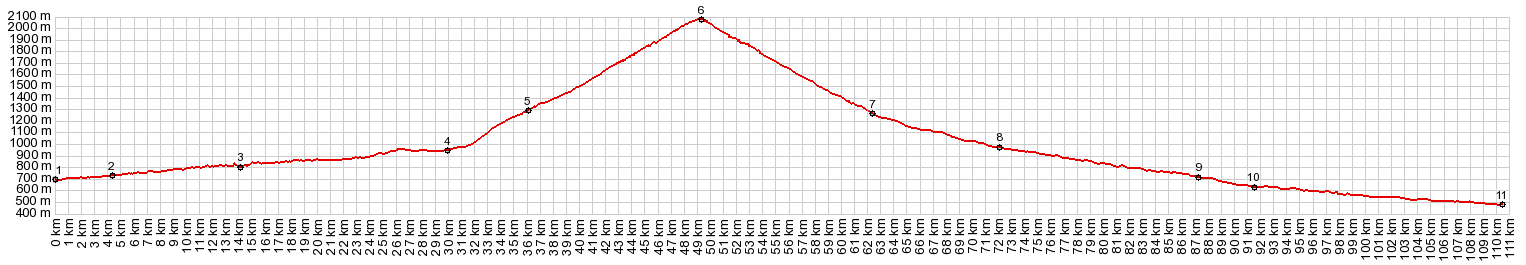
Port de Bonaiqua
Port de la Bonaiqua is an important,
wide highway that crosses the main ridge of the
Pyrenees at over 2000 meters, and that is kept
operational year round. But it is not a "political
border" pass. In this area the Pyrenean main ridge
is completely in Spain. But it is "geographical
border" pass. The north side of this pass is in
Spain, but no longer part of the Iberian
Peninsula. In the records department, this pass
is the highest paved road pass in Catalonia, and
the only paved pass over 2000 meters in the
Spanish Pyrenees. Spain's other 2000 meter plus
passes are in its mountains along the
Mediterranean coast, the Sierra Nevada and the
Sierra de los Filabres.
The first time the climb gets a little more than
just noticeable is where the road bypasses the
village Esterri d'Anneau. It is just a straight
ramp without other features, wide with shoulder -
but boring. An alternate, slightly longer route
goes through the village, and is probably more
interesting from the seat of a bicycle. At point 5, on the other hand, the road has a
very particular feature. For no other reason than
the apparent decision to gain elevation here, it
curves back into a valley to gain a hundred
meters. Continuing up the valley on a sideroad,
goes over the unpaved Pla de Beret summit, which
is about 200 meters lower than this pass,
something you would not expect from looking at a
map the first time.
Past this point the first high peaks come into
view next to the road, Lo Teso and Roca Blanca,
reaching between 2600 and 2700 meters and always
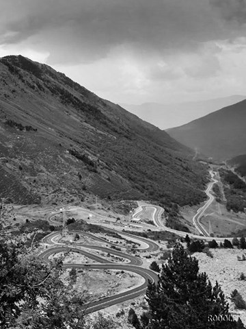
foregrounded by power lines. What follows is a
real spaghetti road with about 17 switchbacks. The
road never reaches up any flank of a mountain, but
just switches back and forth at very bottom of the
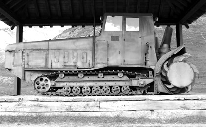
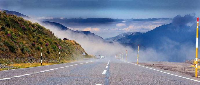
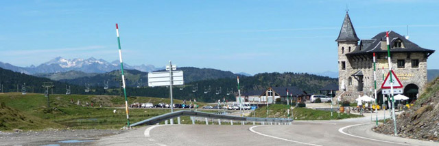
valley, which now reaches above treeline. The top is a busy place, where apparently
everybody has to stop on one of the many dirt
turnoffs. A bar/restaurant is reminiscent of a
copy of a Disney Castle (that is the copy of a
copy of a copy of a castle). Ski lifts disect the
landscape into sharp wedges. Housed under an
protective metal roof stands an old snowcat with a
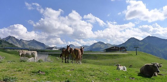
memorial plaque below it. The animal foraging
scene is also quite diverse, and I am not able to
identify all species or attach meaning to all the
monuments. From North. (described
downwards) I see more cyclists over on this
approach than I have encountered since leaving the
Costa Blanca. Rather than following the valley
bottom, here the road does the opposite. It stays
high up on the ridge, along a traverse above the
Vall d'Aran. The result is a fantastic panorama,
and many instantly recognizable pictures with
mountains topping out at a little below 3000
meters. The only thing I did differently with my
pictures, compared to the ones I am able to show,
is that I included more road in the foreground.
Four 180 degree switchbacks step down the
mountain, connected by long ramps. For some this
is not enough curvature. But this is a major
highway, not a remote hilltown road.
For me this is also one more day with crystal
perfectly clear weather and an azure blue sky.
After a long enjoyable descent, and having passed
at least a hundred racing type cyclists, I roll
through the skyscraper skiing condo development
Salardu. It appears closed down, dead and
mothballed into sterility, Manhattan after the
plaque broke out. Ever after this, the road keeps
on dropping, in spite of the fact that it is now
at the valley bottom. The road keeps collecting
one resort after another, becoming more and more
alive and noisy, all nestled under enourmous walls
of mountains. Finally the road passes through
Vielha, a virtual resort city with different
neighborhoods of different hotels, catering to
different kinds of tourists, including cyclists
who want a huge breakfast, and to know that their
bicycle is kept in a save place. Below Vielha the traffic can be very heavy
and at times very unpleasant. But I continued to
profile past my own turnoff up to Col Portillon,
until the road exits the mountains at Chaum.
A Day on a Tour with this point as highest summit: COMPLETELY PAVED: ( < Pic de l'Orri | Col de Peyresourde > ) Port de Bonaiqua : Sort > Rialp > Llavorsi > Port de la Bonaiqua > Salardu > Vielha Notes: gps data and distances are on stolen computer A Dayride with this point as highest summit: PARTIALLY PAVED / UNPAVED: ( < Collado de Creu de Perves | Port de Bales > ) Port de Bonaiqua , Puerto de Beret:: Vielha > Baquera > Puerto de Beret > Isavari > Port de Bonaiqua > Baquera > back to starting point in Vielha with several shopping detours: 60.7miles with 7100ft of climbing in 6:58hrs: (garmin etrex30 r5:19.5.27) Notes: great start weather, light rain return - another broken spoke but easily fixed
|
||||||||||||||||||||||||||||||||||||||||||
|
|
advertisement |
|
|
advertisement |