|
|||||||||||||||||
|
|
|||||||||||||||||
| |
|
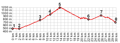
D71 Col d'Illoire s(u)
This is the second highest point on the road, following the
south side of Canyon de Verdun. The western approach goes up
to Col d'Illoire. From the pass, the eastern approach
descends into the canyon on a trail. But the road just keeps
on climbing. The pass is not even close to the summit.
Therefore the point has an s(u) following it. To complete a
route along the eastern side of the Canyon du Verdun, you
still have to go over the higher D71
le Petit Ste Maimes s(u).
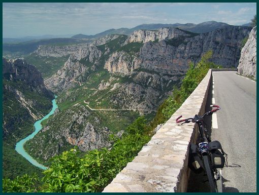
picture page
From West. Right after passing the water sport
activities of Lac de Saint Croix, D19/D71 forks off to the left
and starts climbing. At this point far away from the edge of the
canyon, the first picturesque spot is the town of Aiglunes. It
looks like this place can be pretty busy with tourists. A few
switchbacks higher is the best vantage point on the iron church
tower and the row houses stuck to the hill. Col d'Illoire is
reached quickly, where a sudden drop off into the Canyon of
Verdun becomes visible on the left side of the road. But D71 just keeps on climbing. The most spectacular part is
still ahead, as the road traverses ever higher, opening up a
view of the limestone cliffs sitting over much smaller hills,
that almost look like a plain in comparison. This is very
different than the east side of the canyon. The road on this
side traverses much higher near the mouth of the canyon. From
the other side no such magnificent drop off is visible. Finally
the road crests at an unmarked summit and the map tells us that
this is the highest point. Without an altimeter it actually
feels like the entrance to the D71
Tunnel de Fayet s(u) (also contained in the profile above)
should be the highest point, but the profile shows just how
wrong this is.
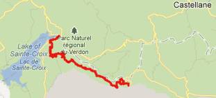
From East. (described downwards). The descend switches
the viewshed to deep incised canyons. The route des Cretes is
now visible on the other side of the canyon, quite a bit higher.
A low point is reached when the road crosses a bridge over the
Canyon de l'Arturby. Tours
A Dayride with this point as intermediate summit is on
the page: Route
des Cretes s(u)
The last summit point with different start and end points on this Extended Tour is: Col de Luens
back to Cycling
Passes in Europe
|
 Approaches