| |
| |
Alto de Jaizkibe
One can get the impression, that all
coastal roads in Europe are traffic nightmares.
Not so this one - even though getting to the
eastern starting point may involve a lot of
traffic. For being so close to the shore this is a
remarkably high summit, with some great views.
The key to getting to the town Hondarribla from
the French side is, that you have to cross the
border on busy N10 (as far as I know), then not
take the first exit, but the second, which first
heads south, and only later north. Spanish exits
are funny that way. Then once on the edge of
Hondarribia and its chateau, that looks so scenic
and characteristically french, from the French
side with all its expansive lawns and expensive
manicured landscaping, the road to Jaizkibe stays
west of the town. The ride through and above the
town is interesting and scenic too, but it leads
back to the same traffic circle west of the beach
town.
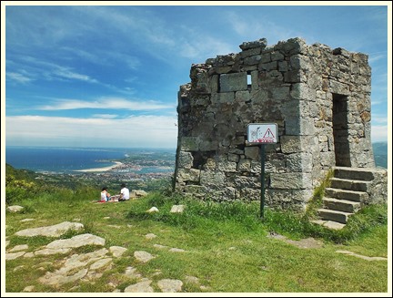
Approaching the summit a minutely small defensive
tower now forms the main attraction for a parking
lot full of cars. A short distance later - at the
real summit - a 2 minute hiking spur leads to a
knoll overlooking the coast in both directions.
That's where I would have built my defensive
tower. On the other side a longer path leads up to
a transmission facility
From West. (described
downwards). This side has many more great Atlantic
views, and the road is actually closer to the
water than on the other side. The road ends at a T
junction at the port of Pasaia. Going right here
means a grand tour of the port - and an eventual
return to this junction. It is a dead end. If not
interested it is better to go left the first time.
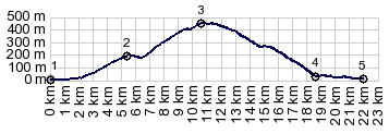
Dayride with this point as highest summit: COMPLETELY PAVED ( < Collado de Ibaneta | Col d'Ibardin > ) Alto de Jaizkibe: St Jean de Luz > Basque Cornice west > Hendaye .> Hondarribla with several detours > Hondarribia > Monte Jaizkibe > Pasaia with detour > N10 north > back to St Jean de Luz with grocery shopping:63.0miles with 4494ft of climbing in 5:55hrs (garmin etrex30 r5:19.6.22) Notes: on the verge of hot. The ride had one more over 300ft climb on N10 between Pasaia and St Jean de Luz. But it is not at least 500ft or 389m above its lowest approach point (in this case sealevel), so I don't count it. |
 As far as this actual route is
concerned, where did all the traffic go ? I guess
it is all just parked at the beach somewhere. This
wide regular road contours up the forested slope
in peace and quiet. The first really magnificent
views of the cracy traffic jams below open up as
the road reaches a quiet chapel with adjacent
park, overlooking the Atlantic end of the
Pyrenees, or do you call them the Cantabrian
Mountains here already ? There are concrete road
spurs to other points above the coast from here. I
started down one, but became worried about the
spokes -very bumpy - mountain bike territory. So I
elected to stay on the road. There, a short
downhill made me question if that was already the
summit. But no - there still is a real workout to
come, and all the good views to the Atlantic side
are still ahead.
As far as this actual route is
concerned, where did all the traffic go ? I guess
it is all just parked at the beach somewhere. This
wide regular road contours up the forested slope
in peace and quiet. The first really magnificent
views of the cracy traffic jams below open up as
the road reaches a quiet chapel with adjacent
park, overlooking the Atlantic end of the
Pyrenees, or do you call them the Cantabrian
Mountains here already ? There are concrete road
spurs to other points above the coast from here. I
started down one, but became worried about the
spokes -very bumpy - mountain bike territory. So I
elected to stay on the road. There, a short
downhill made me question if that was already the
summit. But no - there still is a real workout to
come, and all the good views to the Atlantic side
are still ahead.|
|
advertisement |
|
|
advertisement |