| |
| |
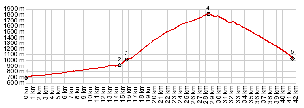
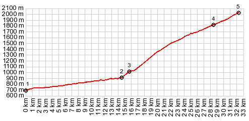
Alto de Pequera s(u)
/ Alto de Rabassa(ow)
Judging from the road graffiti and
cyclist directed sings along the way, this is a
fairly famous climb in the Vuelta d'Espagna. This
explains the size and quality of the road, about
the width of 3 to 4 regular Pyrennean roads,
perfectly smooth asphalt - and once above the last
village - no traffic whatsoever. You don't have to
be a racer to like all that. Scenery is kind of
interesting in peculiar way.
Switchbacks on this side climb
forever through the forest. Views of the mountains
are obscured by trees. There is one place where
some millionare has cleared a meadow for the
oaisis and his own view. It's the best scene along
the way.
From North. (described
downwards) This side is actually much more open
and affords infinitely better views. If there is a
choice of which approach to ride in good light for
taking pictures, this side is definitely it.
Especially one view, the only occasion the road
climbs a little on the descent, in order to get
across an outcrop, is very photogenic - but
actually very untypical for the rest of the road
Sidetrip to La Rabassa s(u) There are more switchbacks where all the last ones came from. On top of the one way climb is another part of the amusement park of some sort. Advertisments for this Naturlandia have been almost as common as the trees during the ride up. But nobody was amusing themselves on this May day. The top is equally tree covered as the southern descent and every peak of the mountains around, and there are plenty - has to be lurked for between the trees. Even walking for half an hour or so up the ski area does not substantially improve that condition. A sign portraying the gradient of the road with various bicycle symbolism further awakens curiosity about the races on this gradient. A computer key on the sign promises to lead to an explanation.
 Dayride with this point as
highest summit: Dayride with this point as
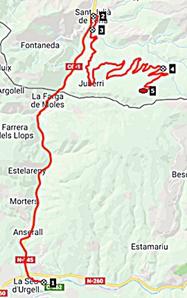
highest summit:( < Collado de Canto | Estany de Montcortes s(u) > ) La Paquera s(u) , additional out and back : La Seu d"Urgell > Sant Julia de Lloria > Juberi > La Paquera s(u) <> out and back to La Rabassa(ow) > Aixirival > Sant Julia de Lloria with bike part shopping detour > back to starting in La Seu d'Urgell: 45.7miles 4997ft 8.9mph 5:06hrs (garmin etrex30 r5:19.5.20) Notes: the day included also a hike from La Rabassa to the next equally tree covered mountain above |
|
|
advertisement |
|
|
advertisement |