| |
| |
Moyenne Corniche(sh)
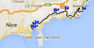
There are three direct routes
that connect Nice with Monaco. In order of
increasing elevation these are the Basse
Corniche, Moyenne Corniche and Grand Corniche.
All three are interesting bike routes. But the
lowest Corniche (Basse) usually has traffic that
is so heavy, that the ride becomes a stop and go
affair, not only for the purpose of taking
pictures. The Moyenne Corniche traverses at half
height between the limestone cliffs, speckled
with white villas and ragged castle ruins on one
side, and the boating extravaganza, floating on
blue sea on the other.
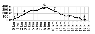
The profile does not traverse the entire Moyenne Corniche, but it does go over its highest point. The profile stays lower in the beginning, then traverses up to its highest point, and descends into Monaco, while the Moyenne Corniche stays higher.
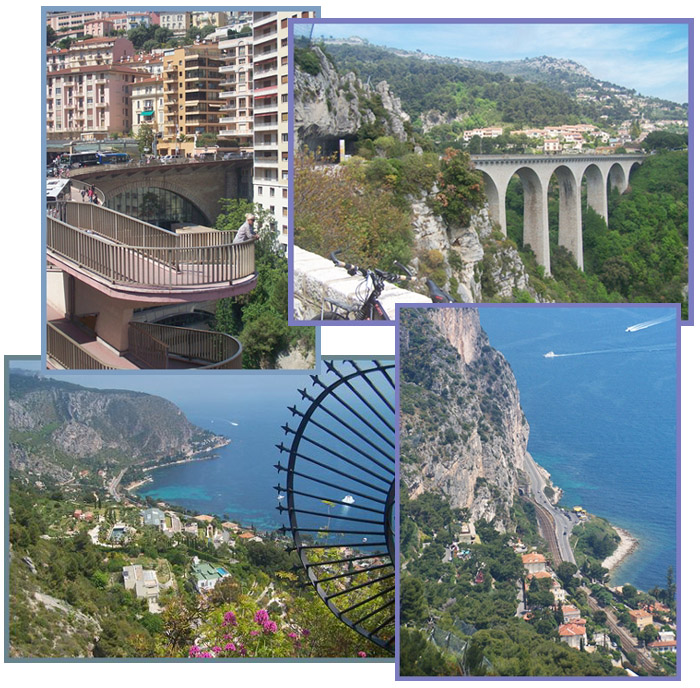
The climb through super residencia quickly
reaches a wider road, the Moyenne Corniche. The
route traverses upwards. Below the cruise ship,
that seems to be an anchored hotel, make an
interesting contrast to what nature has made on
the coast. The road leads trough a short tunnel to
emerge on a picturesque arched bridge into the
town of Eze. The streets of this old medieval
castle are full of tourists, art galleries and
restaurants. As is often the case in places like
this, the best view is reserved for the final
resting place, the cemetary. Fortunately, the
living are allowed to see it too. On the other
side from the town of Eze, a climb leads to Col d'Eze , almost the
highest part of the Grand Corniche. The highest
part of the Moyenne Corniche is a short distance
east of these two turnoffs
From East. (described
downwards). . The road named "Grand Corniche"
stays up on the cliffs all the way to Menton, The
Moyenne Corniche till east of Monaco. But
following the flow of traffic, rolling downhill
the road quickly becomes four lanes and merges
with all the A8 access traffic. All this combined
traffic funnels together, and comes to a
screeching halt when the route enters the traffic
chaos of Monaco. But maybe it's not always as
screeching and halting, as when I experienced it,
during a pre race day of the Grand Prix, ie a race
with vintage Formula 1 cars. From this vantage point, the kingdom resembles a
vertical cliff completely cloaked with luxury high
rise buildings, that have grown together into a
single structure like a bees hive. Far below the
screeching of racing motors, at this altitude the
quiet imperceptible purring of thousands of idling
Mercedeses, Ferraris, Maserattis and whatever
other names man attaches to expensive automobiles.
The steepest housing cliff, neatly flanked by
pedestrian circular staircase is actually the
portal to the underground railroad station. It
looks as adventurous from the inside as from the
outside. It's visible in the center of the top
left photo.
COMPLETELY PAVED: Moyenne Corniche(sh): Ave Ste Margue 237, <> somwhere between 5 and 10 miles worth of loops looking for a suitable grocery store near the starting point > Nice > Nice Port > Basse Corniche east > up Ave Leopold II, Moyenne Corniche west <> out and back to town Eze > Moyenne Corniche west > Monacco > Basse Corniche east > Beaulieau Sur Mere > Nice Port <> loops around Leu Casteu Cemetery, park and ruins on hill east of port > back to staring point: m4: 54.9m with 2791ft of climbing in 5:22hrs (VDO MC1.0 m4:14.5.9). Notes: first exploratory ride around Nice on this tour. Lots of stop and go traffic, another high point of this day was the Leu Casteu cemetery and late light views onto Nice The first day with different start and end points on this tour is on page: Col de Palmarella/ Col de la Croix
|
|
|
advertisement |
|
|
advertisement |