| |
| |
Nigerpass
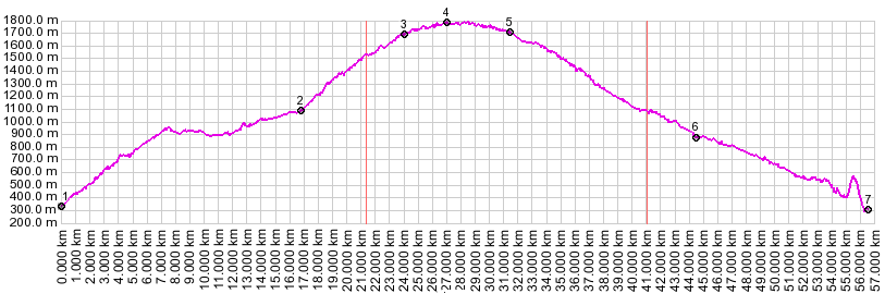
aka Passo Nigra Nigerpass is really an alternate
approach to Karerpass
(Costalunga), which is the main traffic connection
between the Bozen area, and the tourist area of
val di Fassa. The Nigerpass road joins Karerpass 1
km east of its summit. From a cyclist's standpoint
Nigerpass is more interesting than the Bozen side
of Costalunga, because it has less traffic on a
narrower road, is scenically more diverse, and has
a more varied slope, including much steeper
sections. Combined with Costalunga it also makes a
great day ride form Bozen, delivering great views
onto the Rosengarten peaks of the dolomites.
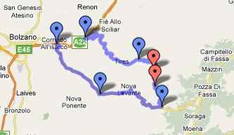
From North. You can leave Bozen heading
north on one of its many, excellent totally
separate bicycle paths. This one follows the river
Eisack (Isarco) north to Brixen. The path is a
little hard to find at first, as it makes its way
under the railway station and then follows the
west side of the river. It later switches to the
east side, following a small bike path art
gallery. The "just for bicycles" road continues up
Brenner Pass.
The turnoff to Nigerpass is signed as direction
Kaestelroth and Voels, at a point before you enter
a tunnel. Best to ask for directions, and even
then plan on getting lost.
From South. (described downwards).It's
just a short roll before the Nigerpass road joins
the busier Karerpass road. Taking a right leads
back down direction Bozen into the Eisack valley,
not far from where the northern approach started.
The upper descent is more tourist frequented, with
bus loads of people wandering around the Karersee
area. Continuing down through the busy tourist
town of Welschnofen ... and then it's a thrill a
second. It all starts with five or six short
tunnels as a warm up, then an incised canyon where
the walls hang over the road, followed by a
1600 meter tunnel, which emerges on a small
bridge, just to enter another 1200 meter tunnel,
all strongly sloping downwards. Both are very well
lit. If ascending on this side, trying to find
this tunnel entrance from the Eisack valley for
the first time can also be tricky. You have to
leave the bike path, just after you see some water
tunnels on the other side of the Eisack. Cross the
road via a short bike bridge, then enter a large
hole in the mountain. But the tunnels can also be
bypassed over an abandoned old road. The turnoff
is to the right over a barricade just before the
first tunnel entrance. More on the Karerpass page.
|
||||||||||||||||||||||||||||||||||||||||||
 Approaches
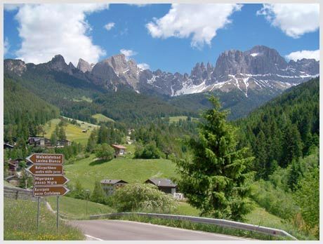
|
|
advertisement |
|
|
advertisement |