|
|||||||||||||||||
|
|
|||||||||||||||||
| |
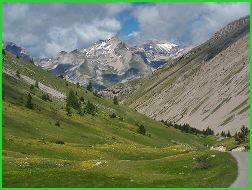
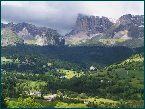
Col de Noyer
The pass connects the Champsaur Valley on the east side with
the Devoluy valley on the west. The ridge has a steep strike
slope with cliff faces on the the east, and a more gradual
dip slope on the west. The mountains in the Devoluy part of
alps are lower than the adjacent ones in the Ecrins National
Park. But they are especially attractive for cyclists
because of several passes, that thread in between the tooth
like cliff faces of these mountains. Col de Noyer has a good
road surface, is fairly narrow, and still appears to have
relatively few motorcycles ( I saw about 10 ), the best of
many worlds.
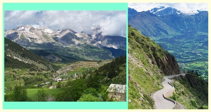
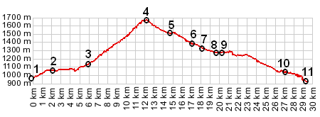
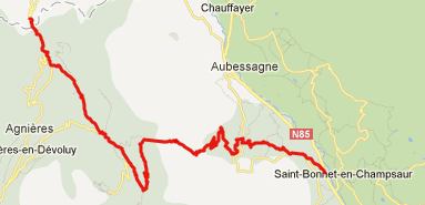
From East. The first chance to get off the busy Route
Napoleon and head for this pass is a different spot, depending
if you come from south or north. I came from the south, so
that's the profile shown, and also the description. There is an
Intermarche supermarket right at the turnoff, perfect location
for last minute carbohydrate shopping, just east of St Bonnet en
Champsaur. The route circuitously collects several sleepy,
picturesque villages on the lower slope, first Poligny, and
others too small to be shown on my map. I saw at least two gites
in these towns, though I don't know about their ouvert status.
At the junction with the approach form the north, near La
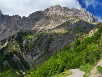
Serre, the climbing becomes more serious. The view of the cliff
face to the south belongs to Bec de l'Aigle 2384m. Mountains
like this one, on the other side of the Chamsaur valley, towards
the Ecrins National Park have a much darker appearance, without
the cliff faces of the mountains in the Devoluy area.
From West. After a fast descend on a fairly narrow
road, it starts climbing again and turns to the left, in order
to head for St Etienne en Devoley. But before passing between
the picturesque houses of this village, the road had to
switchback to the north again. Exiting St Etienne is the
junction with Col de Rioupes. But the profile continues to
descend. Past St Didier another road, coming down from Col
du Festre joins in. Still, there is no traffic to speak of,
that I encountered. You can ride around both sides of the
Solouse Gorge. The more common way is on the west side. Going
around the east involves quite a detour if heading east, but the
smaller road looks very interesting. The profile descends around
the western side to Bge de Sautet, where a bridge crosses the
Drac. Alternatively if heading west, one can contour along the
hills direction St Sebastian - also a very scenic route with
practically no traffic. This is the tour route below.
Col de Noyer: the steep strike surface on the east side History: A first road to replace a mule trail was built in the 1850s. The strategic location of the pass between the two valleys was highlighted by the fact, that Napoleon built six shelters along the route in 1858. The shelter on top is an exact reconstruction of this hut. The original was built in 1854, destroyed by fire in 1947 and reconstructed in 1955. It is now open for business only in the summer. The pass became a less important traffic connection, when a road over Col du Festre was built in the 19th century. Cycling - Tour de France: During the post WW2 years,
this pass was four times on a stage, all fairly recently: 1970,
1971, 1982 and 2010. A day on an Extended Tour: (<Col du Moissiere|Col
de Malissol>)
back to Cycling
Passes in Europe
|
 Approaches