| |
| |
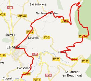
Col de Malissol
This pass is an
intermediate summit on a ride connecting La Mure
with the Gorge de la Romanche. The summit is also
on the profile of a possible highest point of that
route, the Col de
Morte. Loop rides with Col de Malissol as
highest summit curve back down towards La Mure.
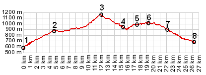
The profile shows one such option
From South. In order to get the most
elevtion gain, the profile starts at the bridge
where D526 crosses the lake of the Drac. D526
merges onto busy N85 and climbs up to La Mure. In
La Mure D114 climbs towards the pass. There are
also many other ways to get to D114 from north of
La Mure. The one I took was a very small path,
impossible to follow on my 1:200 000 scale map. Since the profile shows Col de Malissol as the highest point, the profile takes a right turn at the junction to Las Everras, and descends back to a southern direction, close to the starting point, La Mure. A day on an Extended
Tour with this point as intermediate
summit: (<Col
du Noyer|Col de
la Morte>)
Col de Morte, Col de Malissol: Theafrey > small roads and paths with detours onto D115 > Col de Malissol > Chabotte Moulin Viex > Col de la Morte > up N91 Gorge de la Romanche > Bourg d'Oisans <> a few miles of shopping: 49.2miles with 6090ft of climbing in 4:42hrs |
 Approaches
|
|
advertisement |
|
|
advertisement |