| |
| |
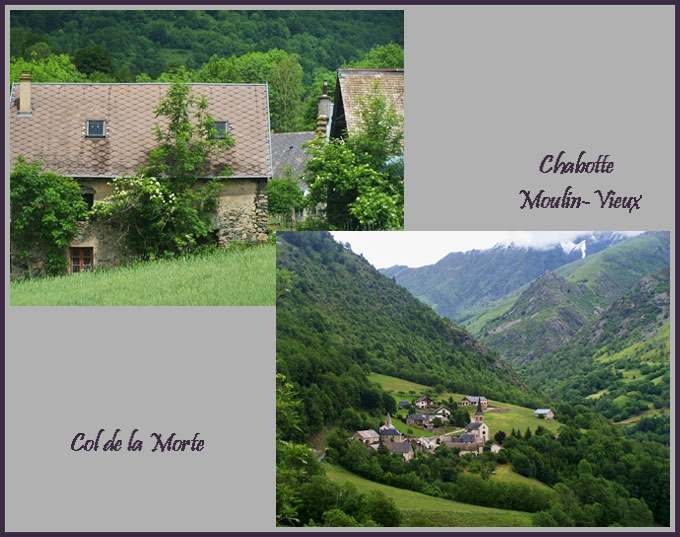
Col de la Morte
One way to reach the
cycling resort Bourg d'Oisans from the south is to
ride over Col de
Marissol and Col de la Morte. The more
obvious route is probably Col de Parquetout and Col d'Ornon. The
route over Col de la Morte is more heavily
forested and has fewer impressive far views, but
instead some really isolated village decay, that
looked especially appealing in the rain to me.
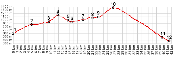
 Approaches ApproachesFrom South. The profile shows an approach over the lower Col de Malissol. The description starts after this descent reaches a low point on D114 in the valley of the Roizonne. The road does some twisting exercises to thread through the centers of the small clusters of houses of Lavaidans. Les Mezoirs is easier, but the houses are just as overgrown from time and vine. At least two of the villages in the valley have public fountains placed under a roof (along with a payphone), which make a great opportunity to get out of the rain, should that be the case. Meanwhile the mountains lining this valley have lost their rounded aunt hive character and acquired a rocky peak look. I don't know exactly where this happened. The clouds revealed them for the first time when approaching Chabotte Moulin-Vieux. A small 1km detour leads to a peaceful bench, that can be used as the ultimate pique-nique site, located at the dead end of the road, and the beginning of a wildly romantic looking valley. Back on D114 the climbing on this side begins in earnest on the opposite facing slope. The illusion of isolation and another time ends on top of the pass at the ski resort La Morte. But this is still a fairly simple resort town - no condo towers. From North
(described downwards). From the top of the descend
you can only catch two glimpses between the trees
of the valley below. But this is a huge drop down
to the Gorge of the Romanche. The road drops
steeply through one long forested ramp to yet
another switchback after another, and the bottom
hardly seems to come closer. Just before D114
reaches N91 in the gorge, it traverses on more
sleepy village, a reminder of the other side of
the pass, that is now behind us. A day on an Extended
Tour with this point as highest summit: (<Col de Malissol|Col du Glandon>)
Col de Morte, Col de Malissol: Theafrey > small roads and paths with detours onto D115 > Col de Malissol(shp?) > Chabotte Moulin Viex > Col de la Morte > up N91 Gorge de la Romanche > Bourg d'Oisans <> a few miles of shopping: 49.2miles with 6090ft of climbing in 4:42hrs |
|
|
advertisement |
|
|
advertisement |